Geographic Region: CHINA
Feature: TAKLA MAKAN, KUNLUN RA.
|
Geographic Region: CHINA Feature: TAKLA MAKAN, KUNLUN RA. |
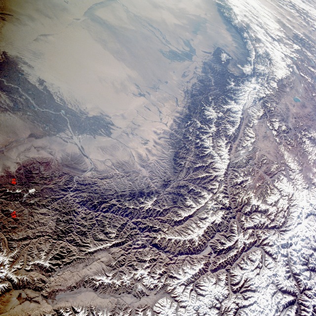 |
| STS040-609-024 Kunlun Mountains and Tarim Basin, China June 1991 The western Kunlun Mountain Range, higher and narrower than the eastern range, and the southern Tarim Basin are visible in this spectacular, east-looking, low-oblique photograph. The Kunlun Mountains extend generally eastward from the Pamir Mountains (northwest of the area pictured in the photograph) for about 1800 miles (2880 kilometers) between the Tibetan Plateau to the south and the Tarim Basin to the north. For most of this distance, the mountains form a north and south double system of ranges, separated by a belt of depressions. The largely inaccessible and uninhabited Kunlun Mountains average 20 000 feet (7000 meters) in elevation, similar to the Himalayas, but contain fewer outstanding peaks. The mineral wealth of the Kunlun Mountains is largely unexplored. The Tarim Basin, a large depression approximately 900 miles (1550 kilometers) long and 300 miles (500 kilometers) wide, is surrounded on three sides by towering mountain ranges. Beneath the belt of gravel along the foot of the mountain ranges, ground water forms from seepage of surface waters fed by mountain snowmelt. At lower elevations is a concentrate belt of finer deposits where ground water irrigates oases (visible in the photograph along the Yarkant River) that have been inhabited by farmers and nomads since ancient times. Visible near the tan northeast portion of the photograph is the Takla Makan, one of the world's driest deserts, with shifting sands interrupted only by patches of clay. One of the many routes of the Silk Road between China and Europe passed through the southern part of the Tarim Basin north of the Kunlun Range. |
| Images: | All Available Images Low-Resolution 194k |
|
| Mission: | STS040 |
|
| Roll - Frame: | 609 - 24 |
|
| Geographical Name: | CHINA |
|
| Features: | TAKLA MAKAN, KUNLUN RA. |
|
| Center Lat x Lon: | 38.0N x 78.0E |
|
| Film Exposure: | N | N=Normal exposure, U=Under exposed, O=Over exposed, F=out of Focus |
| Percentage of Cloud Cover-CLDP: | 10 |
|
| Camera:: | RX |
|
| Camera Tilt: | HO | LO=Low Oblique, HO=High Oblique, NV=Near Vertical |
| Camera Focal Length: | 100 |
|
| Nadir to Photo Center Direction: | The direction from the nadir to the center point, N=North, S=South, E=East, W=West |
|
| Stereo?: | N | Y=Yes there is an adjacent picture of the same area, N=No there isn't |
| Orbit Number: | |
|
| Date: | 199106__ | YYYYMMDD |
| Time: | GMT HHMMSS |
|
| Nadir Lat: | N |
Latitude of suborbital point of spacecraft |
| Nadir Lon: | E |
Longitude of suborbital point of spacecraft |
| Sun Azimuth: | Clockwise angle in degrees from north to the sun measured at the nadir point |
|
| Space Craft Altitude: | nautical miles |
|
| Sun Elevation: | Angle in degrees between the horizon and the sun, measured at the nadir point |
|
| Land Views: | BASIN, MOUNTAIN, DESERT, VALLEY |
|
| Water Views: | DELTA, RIVER |
|
| Atmosphere Views: | |
|
| Man Made Views: | AGRICULTURE |
|
| City Views: | |
|
Photo is not associated with any sequences | ||
| NASA Home Page |
JSC Home Page |
JSC Digital Image Collection |
Earth Science & Remote Sensing |
|
This service is provided by the International Space Station program and the JSC Earth Science & Remote Sensing Unit, ARES Division, Exploration Integration Science Directorate.

|