
Geographic Region: USA-NEW JERSEY
Feature: NE. PA.,NYC,N. NEW JERSEY
|
Geographic Region: USA-NEW JERSEY Feature: NE. PA.,NYC,N. NEW JERSEY |
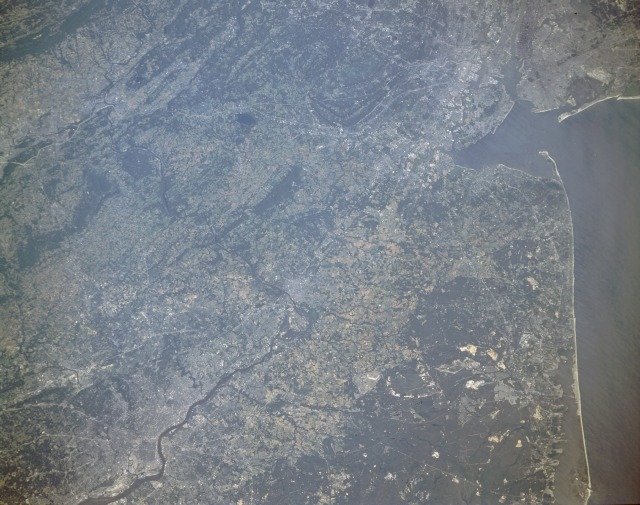 |
| STS040-152-130 Philadelphia, Pennsylvania, and Camden and Trenton, New Jersey, U.S.A. June 1991 Philadelphia, the "City of Brotherly Love" (southwest corner of photograph), can be seen in this northwest-looking, low-oblique photograph. On the west bank of the Delaware River 100 miles (160 kilometers) upstream from the river's mouth lies Philadelphia, the fifth largest city and port in the United States and one of the largest freshwater ports in the world. Having one of nation's largest industrial parks, Philadelphia is a leader in ship repair, oil refining, publishing and printing, insurance, banking, and in the manufacture of textiles, clothing, chemicals, electronic equipment, and metal and machinery products. The seat of many philosophical, artistic, dramatic, musical, and scientific societies, Philadelphia is the home of Independence Hall where the Declaration of Independence was signed and the Liberty Bell. The city is also home to the first daily newspaper and the first established hospital in the United States. Camden, home of the famous poet Walt Whitman, is an industrial city on the east bank of the Delaware River across from Philadelphia. Items manufactured there include canned goods, paper and wood products, chemicals, leather goods, and automobile accessories. Further north, where the Delaware River turns northwest, midway between Philadelphia to the south and New York City to the north, lies Trenton, the capital of New Jersey. Items manufactured there include steel cables, rubber goods, cigars, paint, woolens, textiles, plastics, and metal products. During the American Revolution, Trenton was the site where General Washington crossed the ice-clogged Delaware River from Pennsylvania to surprise and capture the enemy garrison and its 900 troops. The Delaware River, 280 miles (450 kilometers) long, rises in the Catskill Mountains of southeastern New York. The lower Delaware, from Trenton to near Wilmington, Delaware (not visible in the photograph), flows through a highly industrialized region. The Chesapeake-Delaware Canal links the Delaware with Chesapeake Bay (part of the Intracoastal Waterway). Near the northeast corner of the photograph, portions of Newark, New Jersey, and New York City are visible. Part of the famous New Jersey Pine Barrens and coastal areas can be seen (center-east edge to southeast edge of photograph). |
| Images: | All Available Images Low-Resolution 115k |
|
| Mission: | STS040 |
|
| Roll - Frame: | 152 - 130 |
|
| Geographical Name: | USA-NEW JERSEY |
|
| Features: | NE. PA.,NYC,N. NEW JERSEY |
|
| Center Lat x Lon: | 40.5N x 74.5W |
|
| Film Exposure: | N | N=Normal exposure, U=Under exposed, O=Over exposed, F=out of Focus |
| Percentage of Cloud Cover-CLDP: | 0 |
|
| Camera:: | LH |
|
| Camera Tilt: | 31 | LO=Low Oblique, HO=High Oblique, NV=Near Vertical |
| Camera Focal Length: | 90 |
|
| Nadir to Photo Center Direction: | N | The direction from the nadir to the center point, N=North, S=South, E=East, W=West |
| Stereo?: | N | Y=Yes there is an adjacent picture of the same area, N=No there isn't |
| Orbit Number: | 128 |
|
| Date: | 19910613 | YYYYMMDD |
| Time: | 122356 | GMT HHMMSS |
| Nadir Lat: | 39.1N |
Latitude of suborbital point of spacecraft |
| Nadir Lon: | 75W |
Longitude of suborbital point of spacecraft |
| Sun Azimuth: | 83 | Clockwise angle in degrees from north to the sun measured at the nadir point |
| Space Craft Altitude: | 150 | nautical miles |
| Sun Elevation: | 30 | Angle in degrees between the horizon and the sun, measured at the nadir point |
| Land Views: | COAST, PLAIN, HILL, FOREST |
|
| Water Views: | BAY, RIVER, LAGOON |
|
| Atmosphere Views: | |
|
| Man Made Views: | URBAN AREA, AIRPORT, AGRICULTURE, MINING |
|
| City Views: | |
|
Photo is not associated with any sequences | ||
| NASA Home Page |
JSC Home Page |
JSC Digital Image Collection |
Earth Science & Remote Sensing |
|
This service is provided by the International Space Station program and the JSC Earth Science & Remote Sensing Unit, ARES Division, Exploration Integration Science Directorate.

|