
Geographic Region: USA-PENNSYLVANIA
Feature: AREA AROUND WASHINGTON
|
Geographic Region: USA-PENNSYLVANIA Feature: AREA AROUND WASHINGTON |
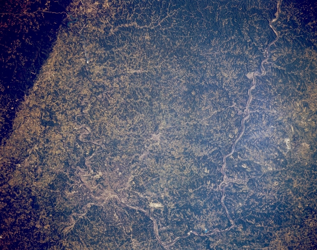 |
| STS040-152-125 Ohio River, Pennsylvania June 1991 The Ohio River makes two 90-degree direction changes before the river begins its southwesterly trek to eventually join the Mississippi River near Cario, Illinois. The first change occurs northwest of Pittsburgh, Pennsylvania and the second change takes place north of Steubenville, Ohio. The location of Pittsburgh can only be determined by finding the confluence of the Monongahela River (the winding, north flowing river), and the southwest flowing Allegheny River (lower left quadrant of the image). The large highly reflective spot west of Pittsburgh (near the bottom center) is the location of the Greater Pittsburgh International Airport. The broad expanse of terrain in this image, consisting of meandering rivers and dissected plateaus, is considered to be part of the Allegheny Plateau. The dark linear feature along the southwest edge of the scene (upper left) is Chestnut Ridge, an elevated, forested, upland, which is part of the Allegheny Mountain system. |
| Images: | All Available Images Low-Resolution 353k |
|
| Mission: | STS040 |
|
| Roll - Frame: | 152 - 125 |
|
| Geographical Name: | USA-PENNSYLVANIA |
|
| Features: | AREA AROUND WASHINGTON |
|
| Center Lat x Lon: | 40.0N x 80.5W |
|
| Film Exposure: | N | N=Normal exposure, U=Under exposed, O=Over exposed, F=out of Focus |
| Percentage of Cloud Cover-CLDP: | 0 |
|
| Camera:: | LH |
|
| Camera Tilt: | 22 | LO=Low Oblique, HO=High Oblique, NV=Near Vertical |
| Camera Focal Length: | 90 |
|
| Nadir to Photo Center Direction: | N | The direction from the nadir to the center point, N=North, S=South, E=East, W=West |
| Stereo?: | N | Y=Yes there is an adjacent picture of the same area, N=No there isn't |
| Orbit Number: | 128 |
|
| Date: | 19910613 | YYYYMMDD |
| Time: | 122249 | GMT HHMMSS |
| Nadir Lat: | 39.0N |
Latitude of suborbital point of spacecraft |
| Nadir Lon: | 80.5W |
Longitude of suborbital point of spacecraft |
| Sun Azimuth: | 80 | Clockwise angle in degrees from north to the sun measured at the nadir point |
| Space Craft Altitude: | 150 | nautical miles |
| Sun Elevation: | 25 | Angle in degrees between the horizon and the sun, measured at the nadir point |
| Land Views: | HILL, PLATEAU |
|
| Water Views: | RIVER |
|
| Atmosphere Views: | |
|
| Man Made Views: | AIRPORT |
|
| City Views: | |
|
Photo is not associated with any sequences | ||
| NASA Home Page |
JSC Home Page |
JSC Digital Image Collection |
Earth Science & Remote Sensing |
|
This service is provided by the International Space Station program and the JSC Earth Science & Remote Sensing Unit, ARES Division, Exploration Integration Science Directorate.

|