
Geographic Region: USA-MARYLAND
Feature: WASHINGTON,DC. AREA
|
Geographic Region: USA-MARYLAND Feature: WASHINGTON,DC. AREA |
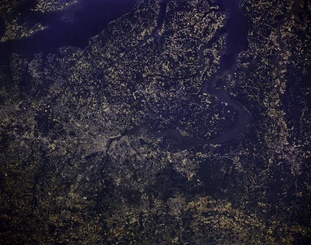 |
| STS040-151-129 Potomac River, Washington, D.C., U.S.A. June 1991 The capital of the United States, Washington, D.C., and it's many suburbs, can be seen in the west-northwest-looking view. Chesapeake Bay is visible traversing across the bottom right portion of the image. The silt-ladened Potomac River can be seen entering the scene midway between the upper center and upper right and traversing the image generally in a southeast direction through Washington, D.C., exiting the scene midway between the bottom left and bottom center. Washington, D.C., is the center of the large metropolitan area and is the legislative, administrative, and judicial center of the United States. The city is also a major tourist attraction. The District of Columbia spreads out over 69 square miles (179 sq. km), including 8 sq. miles (21 sq. km) of water surface. This view of the Washington D.C. region (38.5N, 77.0W) shows the national capital city and many government office buildings in fine detail. The distinctive diagonal street patterns also stand out making this scene easy to identify. The Potomac River, parts of Chesapeake Bay, northern Virginia and the Rappahannock River and many other areas prominent in early American History may easily be located and identified in this highly detailed photo. |
| Images: | All Available Images Low-Resolution 328k |
|
| Mission: | STS040 |
|
| Roll - Frame: | 151 - 129 |
|
| Geographical Name: | USA-MARYLAND |
|
| Features: | WASHINGTON,DC. AREA |
|
| Center Lat x Lon: | 38.5N x 77W |
|
| Film Exposure: | N | N=Normal exposure, U=Under exposed, O=Over exposed, F=out of Focus |
| Percentage of Cloud Cover-CLDP: | 0 |
|
| Camera:: | LH |
|
| Camera Tilt: | 12 | LO=Low Oblique, HO=High Oblique, NV=Near Vertical |
| Camera Focal Length: | 90 |
|
| Nadir to Photo Center Direction: | NW | The direction from the nadir to the center point, N=North, S=South, E=East, W=West |
| Stereo?: | N | Y=Yes there is an adjacent picture of the same area, N=No there isn't |
| Orbit Number: | 66 |
|
| Date: | 19910609 | YYYYMMDD |
| Time: | 152136 | GMT HHMMSS |
| Nadir Lat: | 38.1N |
Latitude of suborbital point of spacecraft |
| Nadir Lon: | 76.6W |
Longitude of suborbital point of spacecraft |
| Sun Azimuth: | 116 | Clockwise angle in degrees from north to the sun measured at the nadir point |
| Space Craft Altitude: | 154 | nautical miles |
| Sun Elevation: | 63 | Angle in degrees between the horizon and the sun, measured at the nadir point |
| Land Views: | PLAIN |
|
| Water Views: | RIVER, ESTUARY, SEDIMENT, BAY |
|
| Atmosphere Views: | |
|
| Man Made Views: | URBAN AREA, AGRICULTURE, PORT |
|
| City Views: | WASHINGTON D.C. |
|
Photo is not associated with any sequences | ||
| NASA Home Page |
JSC Home Page |
JSC Digital Image Collection |
Earth Science & Remote Sensing |
|
This service is provided by the International Space Station program and the JSC Earth Science & Remote Sensing Unit, ARES Division, Exploration Integration Science Directorate.

|