
Geographic Region: USA-VIRGINIA
Feature: CHARLOTTESVILLE AREA
|
Geographic Region: USA-VIRGINIA Feature: CHARLOTTESVILLE AREA |
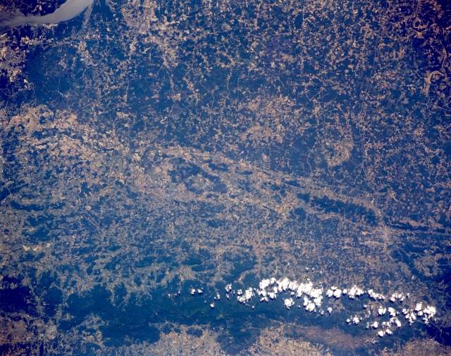 |
| STS040-151-128 Blue Ridge Mountains; Charlottesville, Virginia, U.S.A. June 1991 The boundary separating the Coastal Plain and the Piedmont Region of this section of Virginia can be seen traversing the image from above center left to below center right in this low-oblique image. The upper half of the image shows the gently rolling low forested hills of the Coastal Plain. The lower half of the image shows the Piedmont Region, that is related to the foothills of the Appalachians. The forest-covered Blue Ridge Mountains are visible at the bottom portion of the scene. A small portion of the Potomac River is visible in the upper left of the image. At the right side of the image midway between the clouds over the Blue Ridge Mountains and the Coastal Plain/Piedmont boundary, the city of Charlottesville is barely discernible. The city is located on the Rivanna River, in a Piedmont farm region known for its apples. Charlottesville is the seat of the University of Virginia. Nearby are Monticello, home of the former United States President Thomas Jefferson, and Ashlawn, home of former United States President James Monroe. |
| Images: | All Available Images Low-Resolution 358k |
|
| Mission: | STS040 |
|
| Roll - Frame: | 151 - 128 |
|
| Geographical Name: | USA-VIRGINIA |
|
| Features: | CHARLOTTESVILLE AREA |
|
| Center Lat x Lon: | 38.0N x 78W |
|
| Film Exposure: | N | N=Normal exposure, U=Under exposed, O=Over exposed, F=out of Focus |
| Percentage of Cloud Cover-CLDP: | 5 |
|
| Camera:: | LH |
|
| Camera Tilt: | 8 | LO=Low Oblique, HO=High Oblique, NV=Near Vertical |
| Camera Focal Length: | 90 |
|
| Nadir to Photo Center Direction: | SW | The direction from the nadir to the center point, N=North, S=South, E=East, W=West |
| Stereo?: | N | Y=Yes there is an adjacent picture of the same area, N=No there isn't |
| Orbit Number: | 66 |
|
| Date: | 19910609 | YYYYMMDD |
| Time: | 152121 | GMT HHMMSS |
| Nadir Lat: | 38.3N |
Latitude of suborbital point of spacecraft |
| Nadir Lon: | 77.8W |
Longitude of suborbital point of spacecraft |
| Sun Azimuth: | 115 | Clockwise angle in degrees from north to the sun measured at the nadir point |
| Space Craft Altitude: | 154 | nautical miles |
| Sun Elevation: | 62 | Angle in degrees between the horizon and the sun, measured at the nadir point |
| Land Views: | MOUNTAIN, VALLEY, FOREST |
|
| Water Views: | |
|
| Atmosphere Views: | |
|
| Man Made Views: | AGRICULTURE |
|
| City Views: | |
|
Photo is not associated with any sequences | ||
| NASA Home Page |
JSC Home Page |
JSC Digital Image Collection |
Earth Science & Remote Sensing |
|
This service is provided by the International Space Station program and the JSC Earth Science & Remote Sensing Unit, ARES Division, Exploration Integration Science Directorate.

|