
Geographic Region: USA-VIRGINIA
Feature: HARRISONBURG AREA,I81
|
Geographic Region: USA-VIRGINIA Feature: HARRISONBURG AREA,I81 |
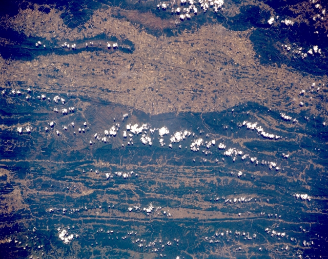 |
| STS040-151-127 Appalachian Mountains Near Harrisonburg, Virginia, U.S.A. June 1991 Portions of the forested Appalachian Mountains near Harrisonburg can be seen in this south-southeast, low oblique view. The Appalachian Mountains are a much-eroded remnant of a great mountain system that formed nearly 300 million years ago by folding of sedimentary rocks. They are covered largely by the most intense deciduous forests anywhere in the world. The Great Appalachian Valley, seen traversing the scene from left to right in the upper portion of the image, is a chain of lowlands extending along most of the systems length. The valley has long been a major north-south highway and is one of the most fertile areas in the eastern United States. Harrisonburg, barely discernible in the central valley, is a processing center in the middle of a poultry, dairy, and livestock area. |
| Images: | All Available Images Low-Resolution 349k |
|
| Mission: | STS040 |
|
| Roll - Frame: | 151 - 127 |
|
| Geographical Name: | USA-VIRGINIA |
|
| Features: | HARRISONBURG AREA,I81 |
|
| Center Lat x Lon: | 38.5N x 79W |
|
| Film Exposure: | N | N=Normal exposure, U=Under exposed, O=Over exposed, F=out of Focus |
| Percentage of Cloud Cover-CLDP: | 10 |
|
| Camera:: | LH |
|
| Camera Tilt: | 3 | LO=Low Oblique, HO=High Oblique, NV=Near Vertical |
| Camera Focal Length: | 90 |
|
| Nadir to Photo Center Direction: | NW | The direction from the nadir to the center point, N=North, S=South, E=East, W=West |
| Stereo?: | N | Y=Yes there is an adjacent picture of the same area, N=No there isn't |
| Orbit Number: | 66 |
|
| Date: | 19910609 | YYYYMMDD |
| Time: | 152107 | GMT HHMMSS |
| Nadir Lat: | 38.4N |
Latitude of suborbital point of spacecraft |
| Nadir Lon: | 78.9W |
Longitude of suborbital point of spacecraft |
| Sun Azimuth: | 114 | Clockwise angle in degrees from north to the sun measured at the nadir point |
| Space Craft Altitude: | 154 | nautical miles |
| Sun Elevation: | 61 | Angle in degrees between the horizon and the sun, measured at the nadir point |
| Land Views: | MOUNTAIN, VALLEY, FOREST |
|
| Water Views: | |
|
| Atmosphere Views: | |
|
| Man Made Views: | AGRICULTURE |
|
| City Views: | |
|
Photo is not associated with any sequences | ||
| NASA Home Page |
JSC Home Page |
JSC Digital Image Collection |
Earth Science & Remote Sensing |
|
This service is provided by the International Space Station program and the JSC Earth Science & Remote Sensing Unit, ARES Division, Exploration Integration Science Directorate.

|