
Geographic Region: USA-CALIFORNIA
Feature: LAKE HAVASU
|
Geographic Region: USA-CALIFORNIA Feature: LAKE HAVASU |
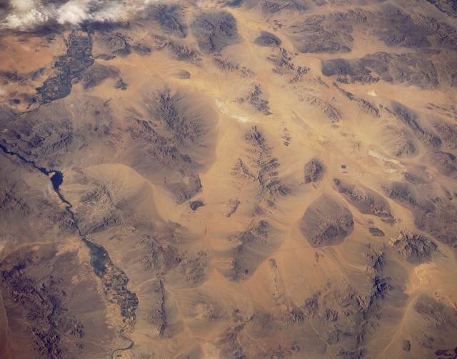 |
| STS040-151-117 Whipple Mountains, Southern California, U.S.A. June 1991 A part of the Colorado River that forms the boundary between California and Arizona is evident near the eastern edge (left side) of the photograph. Irrigated agriculture field patterns are visible in two distinct floodplains along the river. The Whipple Mountains create an eastern protrusion of land that noticeably changes the course of the river. The northwest-southeast-trending Chemehuevi Mountains lie north of the Whipple Mountains, paralleling the Colorado River in California. Parker Dam (beyond the scope of the photograph) on the Colorado River created Lake Havasu, identified by the narrow peninsula that juts southeastward into the Colorado River. Color changes around the bases of the mountains provide visual evidence of erosion. Small segments of Interstate Highway 40 appear in a general east-west alignment. |
| Images: | All Available Images Low-Resolution 269k |
|
| Mission: | STS040 |
|
| Roll - Frame: | 151 - 117 |
|
| Geographical Name: | USA-CALIFORNIA |
|
| Features: | LAKE HAVASU |
|
| Center Lat x Lon: | 34.5N x 115W |
|
| Film Exposure: | N | N=Normal exposure, U=Under exposed, O=Over exposed, F=out of Focus |
| Percentage of Cloud Cover-CLDP: | 5 |
|
| Camera:: | LH |
|
| Camera Tilt: | 38 | LO=Low Oblique, HO=High Oblique, NV=Near Vertical |
| Camera Focal Length: | 90 |
|
| Nadir to Photo Center Direction: | S | The direction from the nadir to the center point, N=North, S=South, E=East, W=West |
| Stereo?: | N | Y=Yes there is an adjacent picture of the same area, N=No there isn't |
| Orbit Number: | 66 |
|
| Date: | 19910609 | YYYYMMDD |
| Time: | 151342 | GMT HHMMSS |
| Nadir Lat: | 36.4N |
Latitude of suborbital point of spacecraft |
| Nadir Lon: | 114.5W |
Longitude of suborbital point of spacecraft |
| Sun Azimuth: | 83 | Clockwise angle in degrees from north to the sun measured at the nadir point |
| Space Craft Altitude: | 152 | nautical miles |
| Sun Elevation: | 32 | Angle in degrees between the horizon and the sun, measured at the nadir point |
| Land Views: | DESERT, MOUNTAIN |
|
| Water Views: | RIVER |
|
| Atmosphere Views: | |
|
| Man Made Views: | |
|
| City Views: | |
|
Photo is not associated with any sequences | ||
| NASA Home Page |
JSC Home Page |
JSC Digital Image Collection |
Earth Science & Remote Sensing |
|
This service is provided by the International Space Station program and the JSC Earth Science & Remote Sensing Unit, ARES Division, Exploration Integration Science Directorate.

|