
Geographic Region: USA-CALIFORNIA
Feature: BARSTOW TO SALTON SEA
|
Geographic Region: USA-CALIFORNIA Feature: BARSTOW TO SALTON SEA |
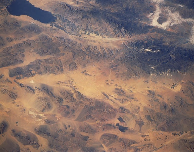 |
| STS040-151-116 Southeastern California, U.S.A. June 1991 This southwest-looking, oblique photograph of southeastern California from the Salton Sea in the south to the southeastern Mojave Desert reveals the browns, tans, and yellows of this arid region. The only extensive area of vegetation lies in the cultivated northern Imperial Valley northwest of the Salton Sea. The dark, irrigated field patterns are barely discernible in the valley between the Santa Rosa Mountains (southwest of the valley) and the southeastern extension of the San Bernardino Mountains (north-northeast side of the valley). Mountains of various elevations and sizes stand in marked contrast with the sandy valleys between the ranges. The isolated, reflective white areas are dry lakebeds. The two darker, irregular features near the lower right side of the photograph are exposed lava beds. |
| Images: | All Available Images Low-Resolution 278k |
|
| Mission: | STS040 |
|
| Roll - Frame: | 151 - 116 |
|
| Geographical Name: | USA-CALIFORNIA |
|
| Features: | BARSTOW TO SALTON SEA |
|
| Center Lat x Lon: | 34.5N x 116.5W |
|
| Film Exposure: | N | N=Normal exposure, U=Under exposed, O=Over exposed, F=out of Focus |
| Percentage of Cloud Cover-CLDP: | 0 |
|
| Camera:: | LH |
|
| Camera Tilt: | 35 | LO=Low Oblique, HO=High Oblique, NV=Near Vertical |
| Camera Focal Length: | 90 |
|
| Nadir to Photo Center Direction: | S | The direction from the nadir to the center point, N=North, S=South, E=East, W=West |
| Stereo?: | N | Y=Yes there is an adjacent picture of the same area, N=No there isn't |
| Orbit Number: | 66 |
|
| Date: | 19910609 | YYYYMMDD |
| Time: | 151325 | GMT HHMMSS |
| Nadir Lat: | 36.1N |
Latitude of suborbital point of spacecraft |
| Nadir Lon: | 115.8W |
Longitude of suborbital point of spacecraft |
| Sun Azimuth: | 82 | Clockwise angle in degrees from north to the sun measured at the nadir point |
| Space Craft Altitude: | 152 | nautical miles |
| Sun Elevation: | 31 | Angle in degrees between the horizon and the sun, measured at the nadir point |
| Land Views: | DESERT, MOUNTAIN, VOLCANO |
|
| Water Views: | LAKE |
|
| Atmosphere Views: | |
|
| Man Made Views: | |
|
| City Views: | |
|
Photo is not associated with any sequences | ||
| NASA Home Page |
JSC Home Page |
JSC Digital Image Collection |
Earth Science & Remote Sensing |
|
This service is provided by the International Space Station program and the JSC Earth Science & Remote Sensing Unit, ARES Division, Exploration Integration Science Directorate.

|