
Geographic Region: USA-CALIFORNIA
Feature: BARSTOW AREA
|
Geographic Region: USA-CALIFORNIA Feature: BARSTOW AREA |
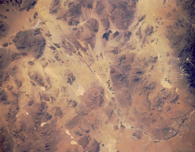 |
| STS040-151-114 Barstow, California, U.S.A. June 1991 The triangular alluvial fan created by past depositional cycles signifies the end point of moisture in the intermittently flowing Mojave River. Within the confines of the fan are dark, cultivated fields where dry farming, particularly center-pivot irrigation, is practiced. Other field patterns appear in close proximity to the Mojave River as it bends gradually southward. Discernible are white, dry lakebeds and two dark, irregularly shaped lava beds southeast of the fan. |
| Images: | All Available Images Low-Resolution 281k |
|
| Mission: | STS040 |
|
| Roll - Frame: | 151 - 114 |
|
| Geographical Name: | USA-CALIFORNIA |
|
| Features: | BARSTOW AREA |
|
| Center Lat x Lon: | 35.0N x 116.5W |
|
| Film Exposure: | N | N=Normal exposure, U=Under exposed, O=Over exposed, F=out of Focus |
| Percentage of Cloud Cover-CLDP: | 0 |
|
| Camera:: | LH |
|
| Camera Tilt: | 26 | LO=Low Oblique, HO=High Oblique, NV=Near Vertical |
| Camera Focal Length: | 90 |
|
| Nadir to Photo Center Direction: | SE | The direction from the nadir to the center point, N=North, S=South, E=East, W=West |
| Stereo?: | N | Y=Yes there is an adjacent picture of the same area, N=No there isn't |
| Orbit Number: | 66 |
|
| Date: | 19910609 | YYYYMMDD |
| Time: | 151301 | GMT HHMMSS |
| Nadir Lat: | 35.6N |
Latitude of suborbital point of spacecraft |
| Nadir Lon: | 117.6W |
Longitude of suborbital point of spacecraft |
| Sun Azimuth: | 81 | Clockwise angle in degrees from north to the sun measured at the nadir point |
| Space Craft Altitude: | 152 | nautical miles |
| Sun Elevation: | 29 | Angle in degrees between the horizon and the sun, measured at the nadir point |
| Land Views: | DESERT, MOUNTAIN |
|
| Water Views: | |
|
| Atmosphere Views: | |
|
| Man Made Views: | |
|
| City Views: | BARSTOW |
|
Photo is not associated with any sequences | ||
| NASA Home Page |
JSC Home Page |
JSC Digital Image Collection |
Earth Science & Remote Sensing |
|
This service is provided by the International Space Station program and the JSC Earth Science & Remote Sensing Unit, ARES Division, Exploration Integration Science Directorate.

|