
Geographic Region: USA-NEW MEXICO
Feature: WHITE SANDS AREA
|
Geographic Region: USA-NEW MEXICO Feature: WHITE SANDS AREA |
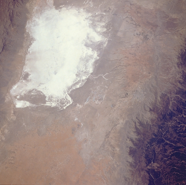 |
| STS039-096-065 White Sands National Monument, New Mexico, U.S.A. May 1991 The highly reflective white sand of south-central New Mexico is easily recognized from spacecraft. White Sands National Monument, established by the U.S. National Park Service, is recognized as the world's largest gypsum sand field with approximately 300 square miles (777 square kilometers). The southwest corner of White Sands National Monument, the lowest spot in the Tularosa Valley, changes from a dry lakebed into Lake Lucero when summer rain falls. This photograph shows no evidence of standing water in Lake Lucero. The sparse, scrub vegetation of the surrounding desert landscape contrasts with the dark, forested Sacramento Mountains, which form part of the eastern edge of the Tularosa Valley. Holloman Air Force Base (center of the photograph) and Alamogordo, northeast of Holloman, are barely discernible. |
| Images: | All Available Images Low-Resolution 290k |
|
| Mission: | STS039 |
|
| Roll - Frame: | 96 - 65 |
|
| Geographical Name: | USA-NEW MEXICO |
|
| Features: | WHITE SANDS AREA |
|
| Center Lat x Lon: | 32.8N x 106W |
|
| Film Exposure: | N | N=Normal exposure, U=Under exposed, O=Over exposed, F=out of Focus |
| Percentage of Cloud Cover-CLDP: | 0 |
|
| Camera:: | HB |
|
| Camera Tilt: | 31 | LO=Low Oblique, HO=High Oblique, NV=Near Vertical |
| Camera Focal Length: | 250 |
|
| Nadir to Photo Center Direction: | W | The direction from the nadir to the center point, N=North, S=South, E=East, W=West |
| Stereo?: | N | Y=Yes there is an adjacent picture of the same area, N=No there isn't |
| Orbit Number: | 72 |
|
| Date: | 19910502 | YYYYMMDD |
| Time: | 203214 | GMT HHMMSS |
| Nadir Lat: | 33.2N |
Latitude of suborbital point of spacecraft |
| Nadir Lon: | 104.7W |
Longitude of suborbital point of spacecraft |
| Sun Azimuth: | 199 | Clockwise angle in degrees from north to the sun measured at the nadir point |
| Space Craft Altitude: | 138 | nautical miles |
| Sun Elevation: | 59 | Angle in degrees between the horizon and the sun, measured at the nadir point |
| Land Views: | DESERT, DUNE, VALLEY |
|
| Water Views: | |
|
| Atmosphere Views: | |
|
| Man Made Views: | |
|
| City Views: | |
|
Photo is not associated with any sequences | ||
| NASA Home Page |
JSC Home Page |
JSC Digital Image Collection |
Earth Science & Remote Sensing |
|
This service is provided by the International Space Station program and the JSC Earth Science & Remote Sensing Unit, ARES Division, Exploration Integration Science Directorate.

|