
Geographic Region: USA-CALIFORNIA
Feature: SALTON SEA,IMPERIAL VAL.
|
Geographic Region: USA-CALIFORNIA Feature: SALTON SEA,IMPERIAL VAL. |
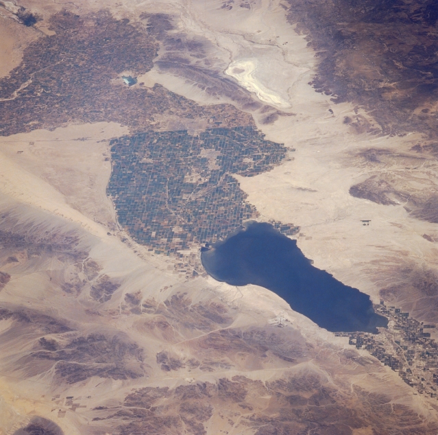 |
| STS039-094-009 Imperial Valley and Salton Sea, California, U.S.A. May 1991 The synoptic view of the southern Imperial Valley of southern California shows a desert landscape transformed by fresh water. The large, irrigated field patterns of the valley are clearly visible near the center of the photograph, with little vegetation discernible east or west. The east-west line of the U.S.-Mexico border is easily identifiable where the cultivated field patterns change dramatically. The highly reflective, elongated feature in Mexico is the Laguna Salada, a lakebed that receives water only intermittently. The darker area west of the Laguna Salada is the northern end of the Juarez Mountains of northern Baja California. The Salton Sea, a large, salty lake 230 feet (70 meters) below sea level, is visible to the north. |
| Images: | All Available Images Low-Resolution 332k |
|
| Mission: | STS039 |
|
| Roll - Frame: | 94 - 9 |
|
| Geographical Name: | USA-CALIFORNIA |
|
| Features: | SALTON SEA,IMPERIAL VAL. |
|
| Center Lat x Lon: | 33.0N x 115.7W |
|
| Film Exposure: | N | N=Normal exposure, U=Under exposed, O=Over exposed, F=out of Focus |
| Percentage of Cloud Cover-CLDP: | 0 |
|
| Camera:: | HB |
|
| Camera Tilt: | LO | LO=Low Oblique, HO=High Oblique, NV=Near Vertical |
| Camera Focal Length: | 250 |
|
| Nadir to Photo Center Direction: | S | The direction from the nadir to the center point, N=North, S=South, E=East, W=West |
| Stereo?: | N | Y=Yes there is an adjacent picture of the same area, N=No there isn't |
| Orbit Number: | 104 |
|
| Date: | 19910504 | YYYYMMDD |
| Time: | 201837 | GMT HHMMSS |
| Nadir Lat: | 36.7N |
Latitude of suborbital point of spacecraft |
| Nadir Lon: | 116.4W |
Longitude of suborbital point of spacecraft |
| Sun Azimuth: | 170 | Clockwise angle in degrees from north to the sun measured at the nadir point |
| Space Craft Altitude: | 145 | nautical miles |
| Sun Elevation: | 59 | Angle in degrees between the horizon and the sun, measured at the nadir point |
| Land Views: | DESERT, |
|
| Water Views: | LAKE, PLAYA |
|
| Atmosphere Views: | |
|
| Man Made Views: | AGRICULTURE |
|
| City Views: | |
|
Photo is not associated with any sequences | ||
| NASA Home Page |
JSC Home Page |
JSC Digital Image Collection |
Earth Science & Remote Sensing |
|
This service is provided by the International Space Station program and the JSC Earth Science & Remote Sensing Unit, ARES Division, Exploration Integration Science Directorate.

|