
Geographic Region: USA-NEVADA
Feature: OWENS LAKE AREA
|
Geographic Region: USA-NEVADA Feature: OWENS LAKE AREA |
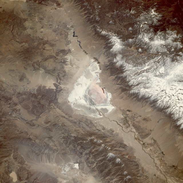 |
| STS039-094-006 Owens Lake, California, U.S.A. May 1991 Before an aqueduct was built to divert water from the Owens River to the city of Los Angeles for its water needs, Owens Lake (center of the photograph) held water in a basin 18 miles (29 kilometers) long and nearly 10 miles (16 kilometers) wide. This south-southwest-looking, low-oblique photograph reveals a dry Lake Owens, north and south of which is seen the Owens River, 120 miles (195 kilometers) long, rising in the Sierra Nevada southeast of Yosemite National Park. West of Owens Lake are snow-covered peaks of the Sierra Nevada and Mount Whitney, the highest mountain in the conterminous United States at 14 494 feet (4421 meters), part of Sequoia National Park. The Inyo Mountain Range and the dark blue waters of the Haiwee Reservoir lie northeast and south, respectively, of Owens Lake. |
| Images: | All Available Images Low-Resolution 140k |
|
| Mission: | STS039 |
|
| Roll - Frame: | 94 - 6 |
|
| Geographical Name: | USA-NEVADA |
|
| Features: | OWENS LAKE AREA |
|
| Center Lat x Lon: | 36.5N x 118W |
|
| Film Exposure: | N | N=Normal exposure, U=Under exposed, O=Over exposed, F=out of Focus |
| Percentage of Cloud Cover-CLDP: | 0 |
|
| Camera:: | HB |
|
| Camera Tilt: | 35 | LO=Low Oblique, HO=High Oblique, NV=Near Vertical |
| Camera Focal Length: | 250 |
|
| Nadir to Photo Center Direction: | S | The direction from the nadir to the center point, N=North, S=South, E=East, W=West |
| Stereo?: | N | Y=Yes there is an adjacent picture of the same area, N=No there isn't |
| Orbit Number: | 104 |
|
| Date: | 19910504 | YYYYMMDD |
| Time: | 201807 | GMT HHMMSS |
| Nadir Lat: | 38.2N |
Latitude of suborbital point of spacecraft |
| Nadir Lon: | 118W |
Longitude of suborbital point of spacecraft |
| Sun Azimuth: | 166 | Clockwise angle in degrees from north to the sun measured at the nadir point |
| Space Craft Altitude: | 145 | nautical miles |
| Sun Elevation: | 57 | Angle in degrees between the horizon and the sun, measured at the nadir point |
| Land Views: | MOUNTAIN, VALLEY, FAULT |
|
| Water Views: | RIVER, LAKE, PLAYA |
|
| Atmosphere Views: | |
|
| Man Made Views: | |
|
| City Views: | |
|
Photo is not associated with any sequences | ||
| NASA Home Page |
JSC Home Page |
JSC Digital Image Collection |
Earth Science & Remote Sensing |
|
This service is provided by the International Space Station program and the JSC Earth Science & Remote Sensing Unit, ARES Division, Exploration Integration Science Directorate.

|