
Geographic Region: USA-ARIZONA
Feature: PHOENIX AREA
|
Geographic Region: USA-ARIZONA Feature: PHOENIX AREA |
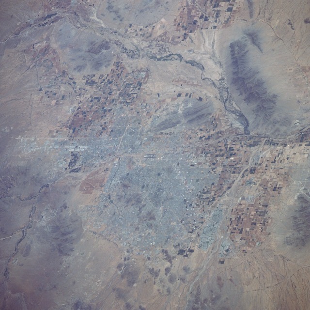 |
| STS039-094-012 Phoenix, Arizona, U.S.A. May 1991 Phoenix, the capital of Arizona, can be seen in this southeast-looking, low-oblique photograph. Located on the banks of the Salt River (southern portion of the photograph), Phoenix is the hub of the rich Salt River Valley cotton and truck farming region. In 1940, Phoenix had a population of nearly 65 000; in 1990, the population had grown to 850 000, with a metropolitan population of more than 2.1 million. Covering 386 square miles (1000 square kilometers) of the former Salt River Oasis and its irrigated farmlands, Phoenix is larger in area than either Chicago or New York City. Phoenix is an important data processing and electronics research center; also manufactured are aircraft and aircraft parts, fabricated metals, machinery, food products, textiles, chemicals, aluminum products, air conditioners, and apparel. The sunny, dry climate has made Phoenix a winter retreat, a noted health resort, and a retirement center. |
| Images: | All Available Images Low-Resolution 132k |
|
| Mission: | STS039 |
|
| Roll - Frame: | 94 - 12 |
|
| Geographical Name: | USA-ARIZONA |
|
| Features: | PHOENIX AREA |
|
| Center Lat x Lon: | 33.5N x 112W |
|
| Film Exposure: | N | N=Normal exposure, U=Under exposed, O=Over exposed, F=out of Focus |
| Percentage of Cloud Cover-CLDP: | 0 |
|
| Camera:: | HB |
|
| Camera Tilt: | 48 | LO=Low Oblique, HO=High Oblique, NV=Near Vertical |
| Camera Focal Length: | 250 |
|
| Nadir to Photo Center Direction: | SE | The direction from the nadir to the center point, N=North, S=South, E=East, W=West |
| Stereo?: | N | Y=Yes there is an adjacent picture of the same area, N=No there isn't |
| Orbit Number: | 104 |
|
| Date: | 19910504 | YYYYMMDD |
| Time: | 201917 | GMT HHMMSS |
| Nadir Lat: | 34.7N |
Latitude of suborbital point of spacecraft |
| Nadir Lon: | 114.4W |
Longitude of suborbital point of spacecraft |
| Sun Azimuth: | 176 | Clockwise angle in degrees from north to the sun measured at the nadir point |
| Space Craft Altitude: | 145 | nautical miles |
| Sun Elevation: | 61 | Angle in degrees between the horizon and the sun, measured at the nadir point |
| Land Views: | VALLEY, MOUNTAIN, PLAIN, HILL |
|
| Water Views: | RIVER |
|
| Atmosphere Views: | |
|
| Man Made Views: | URBAN AREA, AIRPORT, AGRICULTURE |
|
| City Views: | PHOENIX |
|
Photo is not associated with any sequences | ||
| NASA Home Page |
JSC Home Page |
JSC Digital Image Collection |
Earth Science & Remote Sensing |
|
This service is provided by the International Space Station program and the JSC Earth Science & Remote Sensing Unit, ARES Division, Exploration Integration Science Directorate.

|