Geographic Region: KAZAKHSTAN
Feature: LAKE BALKHASH, STEPPES
|
Geographic Region: KAZAKHSTAN Feature: LAKE BALKHASH, STEPPES |
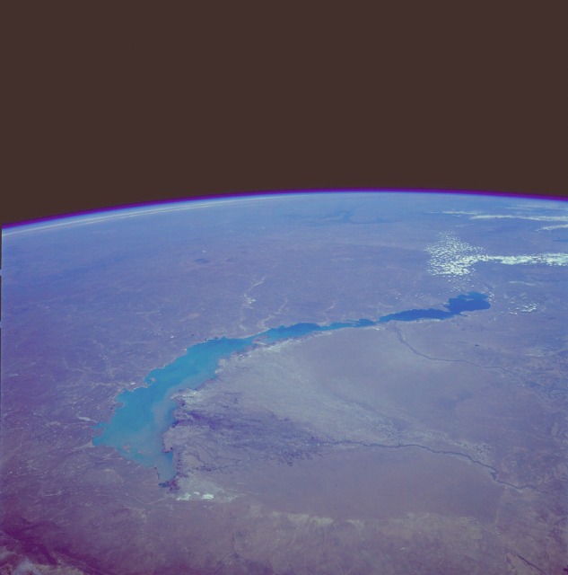 |
| STS039-085-00E Lake Balkhash, Kazakhstan April 1991 The turquoise waters of Lake Balkhash can be seen in this northeast-looking, high-oblique photograph. The lake covers 6560 square miles (17 000 square kilometers), is nearly 350 miles (565 kilometers) long, but is only 45 miles (72 kilometers) at its maximum width. The average depth of Lake Balkhash is 20 feet (6 meters), but the lake reaches a maximum depth of 85 feet (26 meters) in its western half. Lake Balkhash extends from the Betpak Steppe in the west to the Kazakh Hills in the northeast. Visible in the photograph to the north of the lake is a vast undulating plain, and south-southeast of the lake are the Ili River and its delta. The Ili River separates two deserts. The larger, sandy Sary-Ishikotrau Desert lies northeast of the Ili River. A much smaller river, the Karatal, traverses this desert and empties into the eastern portion of Lake Balkhash. The Taukum Desert (brownish color) can be seen southwest of the Ili River. A large sandbar or spit (center of the photograph) separates the eastern, shallower, more saline part of Lake Balkhash from the deeper, fresher water of the western portion of the lake. The Ili River is fed by melting snow and glaciers of the Tien Shan ranges in China south of the lake (not visible in the photograph). Lake Balkhash has no river outlet and, even with the influx of fresh water from the Ili River, is shrinking because of evaporation; however, its rate of shrinkage is much less than that of the Aral Sea, which juts into Kazakhstan much farther to the west. |
| Images: | All Available Images Low-Resolution 54k |
|
| Mission: | STS039 |
|
| Roll - Frame: | 85 - E |
|
| Geographical Name: | KAZAKHSTAN |
|
| Features: | LAKE BALKHASH, STEPPES |
|
| Center Lat x Lon: | 47.0N x 76.0E |
|
| Film Exposure: | N | N=Normal exposure, U=Under exposed, O=Over exposed, F=out of Focus |
| Percentage of Cloud Cover-CLDP: | 5 |
|
| Camera:: | HB |
|
| Camera Tilt: | LO=Low Oblique, HO=High Oblique, NV=Near Vertical |
|
| Camera Focal Length: | 40 |
|
| Nadir to Photo Center Direction: | The direction from the nadir to the center point, N=North, S=South, E=East, W=West |
|
| Stereo?: | Y | Y=Yes there is an adjacent picture of the same area, N=No there isn't |
| Orbit Number: | |
|
| Date: | 1991____ | YYYYMMDD |
| Time: | GMT HHMMSS |
|
| Nadir Lat: | N |
Latitude of suborbital point of spacecraft |
| Nadir Lon: | E |
Longitude of suborbital point of spacecraft |
| Sun Azimuth: | Clockwise angle in degrees from north to the sun measured at the nadir point |
|
| Space Craft Altitude: | nautical miles |
|
| Sun Elevation: | Angle in degrees between the horizon and the sun, measured at the nadir point |
|
| Land Views: | BASIN, DESERT, PLAIN |
|
| Water Views: | LAKE, RIVER, DELTA, SEDIMENT |
|
| Atmosphere Views: | |
|
| Man Made Views: | AGRICULTURE |
|
| City Views: | |
|
Photo is not associated with any sequences | ||
| NASA Home Page |
JSC Home Page |
JSC Digital Image Collection |
Earth Science & Remote Sensing |
|
This service is provided by the International Space Station program and the JSC Earth Science & Remote Sensing Unit, ARES Division, Exploration Integration Science Directorate.

|