Geographic Region: CANADA-NS
Feature: MINAS CHAN./BASIN, AGR.
|
Geographic Region: CANADA-NS Feature: MINAS CHAN./BASIN, AGR. |
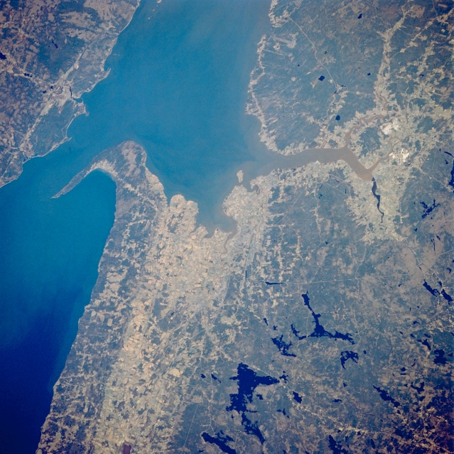 |
| STS039-085-016 Minas Basin, Nova Scotia, Canada May 1991 The Minas Channel (west of pointed peninsula) and the Minas Basin (east of peninsula) are part of the eastern extension of the larger Bay of Fundy. Cape Split is located on the tip of the pointed peninsula that separates these two bodies of water. The tides in the Bay of Fundy are the highest in the world ranging more than 50 feet (15 meters) from low to high tide. The lighter colored landscape shows where the cultivated fields are located. The dark, irregular shaped features inland are lakes, a result of the continental ice sheets that covered Nova Scotia during the Pleistocene era, roughly 15000 to 18000 years ago. |
| Images: | All Available Images Low-Resolution 381k |
|
| Mission: | STS039 |
|
| Roll - Frame: | 85 - 16 |
|
| Geographical Name: | CANADA-NS |
|
| Features: | MINAS CHAN./BASIN, AGR. |
|
| Center Lat x Lon: | 45.0N x 64.5W |
|
| Film Exposure: | N | N=Normal exposure, U=Under exposed, O=Over exposed, F=out of Focus |
| Percentage of Cloud Cover-CLDP: | 0 |
|
| Camera:: | HB |
|
| Camera Tilt: | 21 | LO=Low Oblique, HO=High Oblique, NV=Near Vertical |
| Camera Focal Length: | 250 |
|
| Nadir to Photo Center Direction: | N | The direction from the nadir to the center point, N=North, S=South, E=East, W=West |
| Stereo?: | Y | Y=Yes there is an adjacent picture of the same area, N=No there isn't |
| Orbit Number: | 38 |
|
| Date: | 19910430 | YYYYMMDD |
| Time: | 174540 | GMT HHMMSS |
| Nadir Lat: | 44.1N |
Latitude of suborbital point of spacecraft |
| Nadir Lon: | 64.6W |
Longitude of suborbital point of spacecraft |
| Sun Azimuth: | 215 | Clockwise angle in degrees from north to the sun measured at the nadir point |
| Space Craft Altitude: | 142 | nautical miles |
| Sun Elevation: | 55 | Angle in degrees between the horizon and the sun, measured at the nadir point |
| Land Views: | HILL |
|
| Water Views: | BAY, CHANNEL, LAKE |
|
| Atmosphere Views: | |
|
| Man Made Views: | AGRICULTURE, HIGHWAY |
|
| City Views: | |
|
Photo is not associated with any sequences | ||
| NASA Home Page |
JSC Home Page |
JSC Digital Image Collection |
Earth Science & Remote Sensing |
|
This service is provided by the International Space Station program and the JSC Earth Science & Remote Sensing Unit, ARES Division, Exploration Integration Science Directorate.

|