
Geographic Region: USA-NORTH CAROLINA
Feature: CURRENT BOUNDRY, CAPE HATTERAS
|
Geographic Region: USA-NORTH CAROLINA Feature: CURRENT BOUNDRY, CAPE HATTERAS |
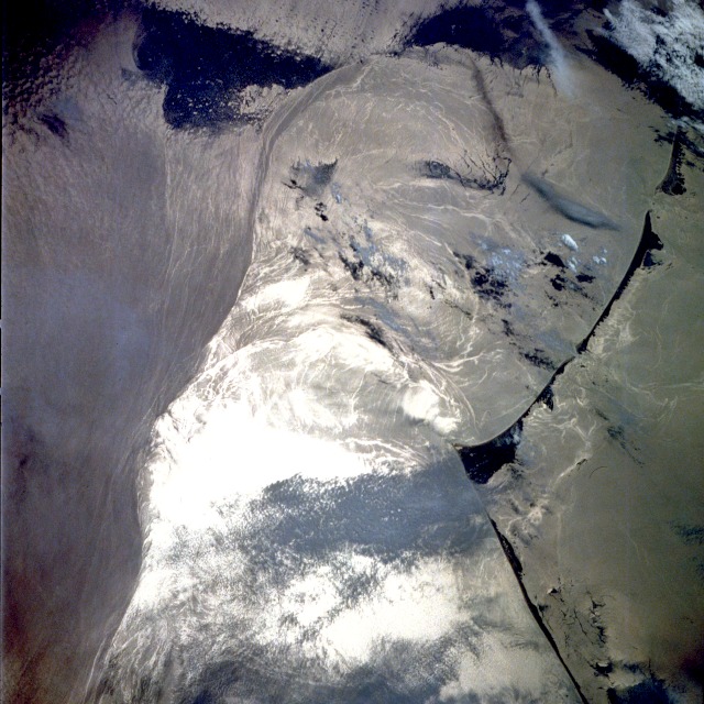 |
| STS039-083-091 Gulf Stream Near Cape Hatteras, North Carolina May 1991 The western boundary (left on image) of the north flowing Gulf Stream is visible in this image. North is towards the bottom. The bright white area seen in the image is the reflection of the sun off the water or sunglint. The waters of Pamlico Sound are visible along the right side of the image. Cape Hatteras and the accompanying Barrier Sand Islands can be seen to the east of the waters of Pamilco Sound. The Gulf Stream Ocean current flows north in the western Atlantic Ocean 10 to 500 miles (16 to 800 km) east of the coast of the United States. The Gulf Stream is not a "river of hot water", but is instead a narrow (60 miles--100 km) high velocity flow of water that separates the cold, dense water to the west near the coast of the eastern United States, from the warm waters of Sargasso Sea to the Gulf Stream's east. The current extends from near the Straits of Florida to an area off of the Grand Banks near 40 degrees north latitude, 50 degrees west longitude. Near Cape Hatteras, the Gulf Stream widens as it begins to flow over the continental rise. The current also begins to grow deeper reaching down to depths of 13000 to 16000 feet (4000 to 5000 meters). Water temperatures in the Sargasso Sea range from near 68 to 75 degrees F (20 to 24 degrees C). Coastal waters near the eastern United States range from 54 to 68 degrees F (12-20 degrees C). At the Grand Banks, the Gulf Stream turns to the east and becomes the North Atlantic Current. In this view of Cape Hatteras, NC (35.0N, 75.5W) the barrier islands appear off the coast in sunglint. Sun light reflected from the water's surface makes patterns that indicate the surface condition. Smooth water has a high reflectance and is seen as a bright area. Rough water on the other hand, disperses the light and appears dark. Ocean currents in this region are very dynamic because of the Gulf Stream interacting with ocean currents. |
| Images: | All Available Images Low-Resolution 139k |
|
| Mission: | STS039 |
|
| Roll - Frame: | 83 - 91 |
|
| Geographical Name: | USA-NORTH CAROLINA |
|
| Features: | CURRENT BOUNDRY, CAPE HATTERAS |
|
| Center Lat x Lon: | 35.0N x 75.5W |
|
| Film Exposure: | N | N=Normal exposure, U=Under exposed, O=Over exposed, F=out of Focus |
| Percentage of Cloud Cover-CLDP: | 5 |
|
| Camera:: | HB |
|
| Camera Tilt: | 45 | LO=Low Oblique, HO=High Oblique, NV=Near Vertical |
| Camera Focal Length: | 250 |
|
| Nadir to Photo Center Direction: | W | The direction from the nadir to the center point, N=North, S=South, E=East, W=West |
| Stereo?: | N | Y=Yes there is an adjacent picture of the same area, N=No there isn't |
| Orbit Number: | 23 |
|
| Date: | 19910429 | YYYYMMDD |
| Time: | 192510 | GMT HHMMSS |
| Nadir Lat: | 35.9N |
Latitude of suborbital point of spacecraft |
| Nadir Lon: | 73.3W |
Longitude of suborbital point of spacecraft |
| Sun Azimuth: | 248 | Clockwise angle in degrees from north to the sun measured at the nadir point |
| Space Craft Altitude: | 141 | nautical miles |
| Sun Elevation: | 49 | Angle in degrees between the horizon and the sun, measured at the nadir point |
| Land Views: | COAST, CAPE |
|
| Water Views: | OCEAN, FRONT, SULOY, SUNGLINT |
|
| Atmosphere Views: | |
|
| Man Made Views: | |
|
| City Views: | |
|
Photo is not associated with any sequences | ||
| NASA Home Page |
JSC Home Page |
JSC Digital Image Collection |
Earth Science & Remote Sensing |
|
This service is provided by the International Space Station program and the JSC Earth Science & Remote Sensing Unit, ARES Division, Exploration Integration Science Directorate.

|