Geographic Region: RUSSIAN FEDERATION
Feature: KAMCHATKA-C. SHIPUNSKIY
|
Geographic Region: RUSSIAN FEDERATION Feature: KAMCHATKA-C. SHIPUNSKIY |
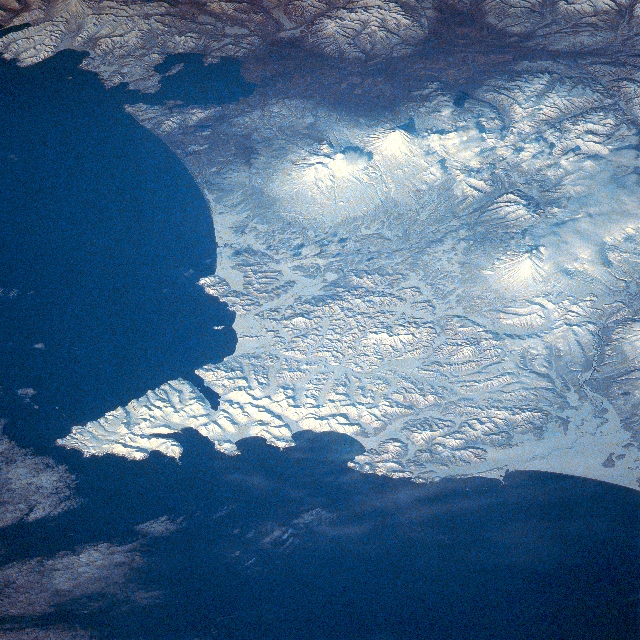 |
| STS039-081-00X Shipunsk Peninsula, Kamchatka, Russia May 1991 The mountainous snow-covered Shipunsk Peninsula can be seen in this southwest-looking view. The Shipunsk Peninsula's (arrowhead-shaped feature) is located on the eastern coast of the rugged and volcanic 750 mile (1208 km) long Kamchatka Peninsula of far eastern Russia. In the upper left part of the image, Avachinsk Bay, an inlet of the Pacific Ocean, and home to the large Russian Naval Base at Petropavlovsk, is visible. The Avacha River Valley (not snow-covered) is discernible traversing northwest across the upper portion of the image. Slightly above the center of the image, the snow-covered stratovolcano, Avachinskaya, which last erupted in January 1991, is visible. To the right of Avachinskaya Volcano is the 11339-foot (3456 meters) high snow-covered stratovolcano Karyakskaya. This active volcano last erupted during the winter of 1956-1957. Below and slightly to the right of the two previously mentioned volcanoes, is the snow-covered and partially cloud covered Zhupanovskaya Volcano (near the right center of the image). This volcano last erupted in 1959. |
| Images: | All Available Images Low-Resolution 423k |
|
| Mission: | STS039 |
|
| Roll - Frame: | 81 - X |
|
| Geographical Name: | RUSSIAN FEDERATION |
|
| Features: | KAMCHATKA-C. SHIPUNSKIY |
|
| Center Lat x Lon: | 53.5N x 159.5E |
|
| Film Exposure: | N | N=Normal exposure, U=Under exposed, O=Over exposed, F=out of Focus |
| Percentage of Cloud Cover-CLDP: | 10 |
|
| Camera:: | HB |
|
| Camera Tilt: | LO=Low Oblique, HO=High Oblique, NV=Near Vertical |
|
| Camera Focal Length: | 250 |
|
| Nadir to Photo Center Direction: | The direction from the nadir to the center point, N=North, S=South, E=East, W=West |
|
| Stereo?: | N | Y=Yes there is an adjacent picture of the same area, N=No there isn't |
| Orbit Number: | |
|
| Date: | 1991____ | YYYYMMDD |
| Time: | GMT HHMMSS |
|
| Nadir Lat: | N |
Latitude of suborbital point of spacecraft |
| Nadir Lon: | E |
Longitude of suborbital point of spacecraft |
| Sun Azimuth: | Clockwise angle in degrees from north to the sun measured at the nadir point |
|
| Space Craft Altitude: | nautical miles |
|
| Sun Elevation: | Angle in degrees between the horizon and the sun, measured at the nadir point |
|
| Land Views: | VOLCANO, MOUNTAIN, VALLEY, PENINSULA |
|
| Water Views: | BAY |
|
| Atmosphere Views: | |
|
| Man Made Views: | |
|
| City Views: | |
|
Photo is not associated with any sequences | ||
| NASA Home Page |
JSC Home Page |
JSC Digital Image Collection |
Earth Science & Remote Sensing |
|
This service is provided by the International Space Station program and the JSC Earth Science & Remote Sensing Unit, ARES Division, Exploration Integration Science Directorate.

|