
Geographic Region: RUSSIAN FEDERATION
Feature: VOLGA R. DEL.-ASTRAKHAN
|
Geographic Region: RUSSIAN FEDERATION Feature: VOLGA R. DEL.-ASTRAKHAN |
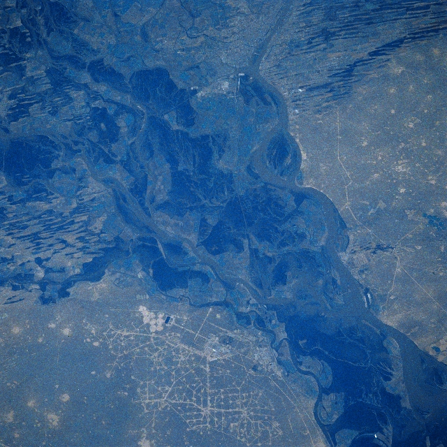 |
| STS039-080-048 Volga River Delta, Russia May 1991 The main channel of the Volga River (lower right corner) fans out into several channels as the river enters the northern edge of the large Volga River Delta. The lighter-colored, muddy-looking water of the Volga can be seen mixing with the extensive water of the very low-lying, more stagnant, swampy water of the delta. The paralleling, east-west aligned features (upper right and left middle) are alternating sand ridges (light lines) that are separated by numerous lakes (dark, linear-looking features). There are more than 700 salt lakes included within the salt marshes of the Volga River Delta. The important Russian city of Astrakan with a population that exceeds 500000 people is visible (upper center). Astrakan has developed into a vital urban area in spite of the fact that it is 72 feet (22 meters) below sea level. The city's growth has been aided by several important factors including irrigated agriculture; natural gas production; source of medicinal materials and salts; an abundance of building products, such as sand and limestone; and water fowl and fish habitats. A variety of industrial activities, including a large producing gas field (pattern of intersecting, light-colored lines - bottom center) that is located along the east bank of the Volga River, has also helped Astrakan become an important city in this semiarid, steppe climate. |
| Images: | All Available Images Low-Resolution 393k |
|
| Mission: | STS039 |
|
| Roll - Frame: | 80 - 48 |
|
| Geographical Name: | RUSSIAN FEDERATION |
|
| Features: | VOLGA R. DEL.-ASTRAKHAN |
|
| Center Lat x Lon: | 46.5N x 48.0E |
|
| Film Exposure: | N | N=Normal exposure, U=Under exposed, O=Over exposed, F=out of Focus |
| Percentage of Cloud Cover-CLDP: | 0 |
|
| Camera:: | HB |
|
| Camera Tilt: | 29 | LO=Low Oblique, HO=High Oblique, NV=Near Vertical |
| Camera Focal Length: | 250 |
|
| Nadir to Photo Center Direction: | SE | The direction from the nadir to the center point, N=North, S=South, E=East, W=West |
| Stereo?: | N | Y=Yes there is an adjacent picture of the same area, N=No there isn't |
| Orbit Number: | 17 |
|
| Date: | 19910429 | YYYYMMDD |
| Time: | 102321 | GMT HHMMSS |
| Nadir Lat: | 47.6N |
Latitude of suborbital point of spacecraft |
| Nadir Lon: | 47.3E |
Longitude of suborbital point of spacecraft |
| Sun Azimuth: | 218 | Clockwise angle in degrees from north to the sun measured at the nadir point |
| Space Craft Altitude: | 143 | nautical miles |
| Sun Elevation: | 51 | Angle in degrees between the horizon and the sun, measured at the nadir point |
| Land Views: | DUNE |
|
| Water Views: | DELTA, CHANNEL, RIVER |
|
| Atmosphere Views: | |
|
| Man Made Views: | DRILLING |
|
| City Views: | |
|
Photo is not associated with any sequences | ||
| NASA Home Page |
JSC Home Page |
JSC Digital Image Collection |
Earth Science & Remote Sensing |
|
This service is provided by the International Space Station program and the JSC Earth Science & Remote Sensing Unit, ARES Division, Exploration Integration Science Directorate.

|