
Geographic Region: KUWAIT
Feature: BURQAN, WAFRAH FIRES
|
Geographic Region: KUWAIT Feature: BURQAN, WAFRAH FIRES |
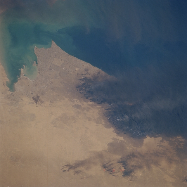 |
| STS039-609-062 Al Burqan Oil Field Fires, Kuwait May 1991 The oil well fires started by the government of Iraq's military, in the Al Burqan oil field situated to the south of Kuwait City (left of the center of the image), can be seen in this northeast-looking view. The image was obtained nearly eight weeks after the fires were started in Kuwait as part of the Iraq's Government "scorched-earth" policy. At the time of this image, over 365 oil wells in the greater Al Burqan fields were burning, as were pools of oil around some wellheads. The thick black smoke from the burning oil wells was being blown by surface winds to the east-southeast out over the Persian Gulf towards southern Iran. Near the lower right of the image, oil-laden sands are visible. Discernible in the upper left portion of the image are some smoke plumes from the burning Al Rawdatayn and Al Sabiriyah oil fields north of Kuwait City. |
| Images: | All Available Images Low-Resolution 229k |
|
| Mission: | STS039 |
|
| Roll - Frame: | 609 - 62 |
|
| Geographical Name: | KUWAIT |
|
| Features: | BURQAN, WAFRAH FIRES |
|
| Center Lat x Lon: | 29.0N x 48.0E |
|
| Film Exposure: | N | N=Normal exposure, U=Under exposed, O=Over exposed, F=out of Focus |
| Percentage of Cloud Cover-CLDP: | 0 |
|
| Camera:: | RX |
|
| Camera Tilt: | LO | LO=Low Oblique, HO=High Oblique, NV=Near Vertical |
| Camera Focal Length: | 250 |
|
| Nadir to Photo Center Direction: | SE | The direction from the nadir to the center point, N=North, S=South, E=East, W=West |
| Stereo?: | N | Y=Yes there is an adjacent picture of the same area, N=No there isn't |
| Orbit Number: | 112 |
|
| Date: | 19910505 | YYYYMMDD |
| Time: | 094700 | GMT HHMMSS |
| Nadir Lat: | 33.3N |
Latitude of suborbital point of spacecraft |
| Nadir Lon: | 42.0E |
Longitude of suborbital point of spacecraft |
| Sun Azimuth: | 209 | Clockwise angle in degrees from north to the sun measured at the nadir point |
| Space Craft Altitude: | 142 | nautical miles |
| Sun Elevation: | 71 | Angle in degrees between the horizon and the sun, measured at the nadir point |
| Land Views: | DESERT |
|
| Water Views: | GULF |
|
| Atmosphere Views: | SMOKE |
|
| Man Made Views: | DRILLING |
|
| City Views: | |
|
Photo is not associated with any sequences | ||
| NASA Home Page |
JSC Home Page |
JSC Digital Image Collection |
Earth Science & Remote Sensing |
|
This service is provided by the International Space Station program and the JSC Earth Science & Remote Sensing Unit, ARES Division, Exploration Integration Science Directorate.

|