Geographic Region: UK-SCOTLAND
Feature: KILBRANNIAN SOUND
|
Geographic Region: UK-SCOTLAND Feature: KILBRANNIAN SOUND |
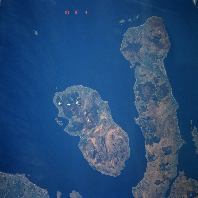 |
| STS039-609-046 Arran Island, Kintyre Peninsula, Great Britain May 1991 Located southwest of Glasgow, Scotland (not in the image), Arran Island and the Kintyre Peninsula are visible in this near-nadir view. Kintyre Peninsula (right portion of the image) extends south (top of the image) from the Scottish Mainland and is 42 miles (68 km) long and 10 miles (16 km) wide. The terrain of the peninsula is hilly and uncultivated. To the left (east) of the Kintyre Peninsula is Kilbrannan Sound. This channel is 14 miles (23 km) long and 4 miles (6 km) wide and is part of the Firth of Clyde. To the left (east) of Kilbrannan Sound is Arran Island. Arran Island covers an area of 165 sq. miles (427 sq. km). The island is largely granitic and sparsely populated with its highest elevation at Goat Fell Mountain near the Island's northeast coast (bottom center) at 2863 feet (873 meters). Arran Island's scenery and its hunting and fishing have made the island a popular vacation area. |
| Images: | All Available Images Low-Resolution 307k |
|
| Mission: | STS039 |
|
| Roll - Frame: | 609 - 46 |
|
| Geographical Name: | UK-SCOTLAND |
|
| Features: | KILBRANNIAN SOUND |
|
| Center Lat x Lon: | 55.5N x 5.5W |
|
| Film Exposure: | N | N=Normal exposure, U=Under exposed, O=Over exposed, F=out of Focus |
| Percentage of Cloud Cover-CLDP: | 0 |
|
| Camera:: | RX |
|
| Camera Tilt: | NV | LO=Low Oblique, HO=High Oblique, NV=Near Vertical |
| Camera Focal Length: | 250 |
|
| Nadir to Photo Center Direction: | E | The direction from the nadir to the center point, N=North, S=South, E=East, W=West |
| Stereo?: | Y | Y=Yes there is an adjacent picture of the same area, N=No there isn't |
| Orbit Number: | 112 |
|
| Date: | 19910505 | YYYYMMDD |
| Time: | 093600 | GMT HHMMSS |
| Nadir Lat: | 56.8N |
Latitude of suborbital point of spacecraft |
| Nadir Lon: | 10.7W |
Longitude of suborbital point of spacecraft |
| Sun Azimuth: | 120 | Clockwise angle in degrees from north to the sun measured at the nadir point |
| Space Craft Altitude: | 141 | nautical miles |
| Sun Elevation: | 37 | Angle in degrees between the horizon and the sun, measured at the nadir point |
| Land Views: | COAST, ISLAND, PENINSULA, HILL |
|
| Water Views: | SEA |
|
| Atmosphere Views: | |
|
| Man Made Views: | |
|
| City Views: | |
|
Photo is not associated with any sequences | ||
| NASA Home Page |
JSC Home Page |
JSC Digital Image Collection |
Earth Science & Remote Sensing |
|
This service is provided by the International Space Station program and the JSC Earth Science & Remote Sensing Unit, ARES Division, Exploration Integration Science Directorate.

|