Geographic Region: JAPAN
Feature: HIROSHIMA, KURE
|
Geographic Region: JAPAN Feature: HIROSHIMA, KURE |
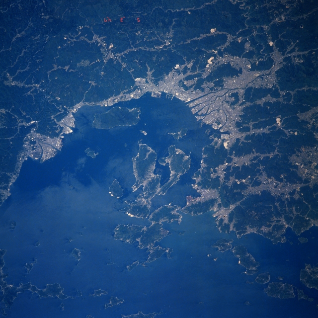 |
| STS039-609-010 Hiroshima Area, Honshu, Japan May 1991 The Japanese city of Hiroshima, known as the "City of Peace" or the "City of Water," can be located on the image (lighter-looking landscape) where six distributary channels (dark, linear features) of the Ota River has formed a large delta upon which the city has developed (slightly above the right of center). The light-colored areas show where human development has taken place, either in the form of towns and cities or as limited agricultural areas. In this particular scene human presence is mainly found along the periphery of the Inland Sea and in the mountain valleys. The dominating terrain in this image consists of rugged, forested mountains (darker areas). Note that the Inland Sea has a myriad of islands of varying shapes and sizes. |
| Images: | All Available Images Low-Resolution 341k |
|
| Mission: | STS039 |
|
| Roll - Frame: | 609 - 10 |
|
| Geographical Name: | JAPAN |
|
| Features: | HIROSHIMA, KURE |
|
| Center Lat x Lon: | 34.0N x 132.5E |
|
| Film Exposure: | N | N=Normal exposure, U=Under exposed, O=Over exposed, F=out of Focus |
| Percentage of Cloud Cover-CLDP: | 0 |
|
| Camera:: | RX |
|
| Camera Tilt: | LO | LO=Low Oblique, HO=High Oblique, NV=Near Vertical |
| Camera Focal Length: | 250 |
|
| Nadir to Photo Center Direction: | SE | The direction from the nadir to the center point, N=North, S=South, E=East, W=West |
| Stereo?: | N | Y=Yes there is an adjacent picture of the same area, N=No there isn't |
| Orbit Number: | 108 |
|
| Date: | 19910505 | YYYYMMDD |
| Time: | 034700 | GMT HHMMSS |
| Nadir Lat: | 37.0N |
Latitude of suborbital point of spacecraft |
| Nadir Lon: | 129.5E |
Longitude of suborbital point of spacecraft |
| Sun Azimuth: | 199 | Clockwise angle in degrees from north to the sun measured at the nadir point |
| Space Craft Altitude: | 141 | nautical miles |
| Sun Elevation: | 68 | Angle in degrees between the horizon and the sun, measured at the nadir point |
| Land Views: | MOUNTAIN |
|
| Water Views: | SEA, RIVER |
|
| Atmosphere Views: | |
|
| Man Made Views: | URBAN AREA |
|
| City Views: | |
|
Photo is not associated with any sequences | ||
| NASA Home Page |
JSC Home Page |
JSC Digital Image Collection |
Earth Science & Remote Sensing |
|
This service is provided by the International Space Station program and the JSC Earth Science & Remote Sensing Unit, ARES Division, Exploration Integration Science Directorate.

|