
Geographic Region: USA-MONTANA
Feature: BEAR PAW MTNS., MO. R.
|
Geographic Region: USA-MONTANA Feature: BEAR PAW MTNS., MO. R. |
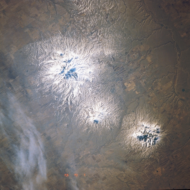 |
| STS039-604-036 Sweet Grass Hills, Montana, U.S.A. May 1991 The snow-covered buttes of the Sweet Grass Hills, near the border of Montana and Alberta, Canada, are visible in this southeast-looking, low-oblique photograph. Each of the hills, formed approximately 50 million years ago, is a miniature mountain range composed of igneous intrusions and older sediment rocks. During the Bull Lake Ice Age, the great glacier flowed around the three big buttes of the Sweet Grass Hills, leaving them to stand as islands above a sea of ice. Visible is the narrow valley of the Milk River in southern Alberta, Canada (lower left). |
| Images: | All Available Images Low-Resolution 347k |
|
| Mission: | STS039 |
|
| Roll - Frame: | 604 - 36 |
|
| Geographical Name: | USA-MONTANA |
|
| Features: | BEAR PAW MTNS., MO. R. |
|
| Center Lat x Lon: | 48.5N x 109.5W |
|
| Film Exposure: | N | N=Normal exposure, U=Under exposed, O=Over exposed, F=out of Focus |
| Percentage of Cloud Cover-CLDP: | 10 |
|
| Camera:: | RX |
|
| Camera Tilt: | 50 | LO=Low Oblique, HO=High Oblique, NV=Near Vertical |
| Camera Focal Length: | 250 |
|
| Nadir to Photo Center Direction: | E | The direction from the nadir to the center point, N=North, S=South, E=East, W=West |
| Stereo?: | N | Y=Yes there is an adjacent picture of the same area, N=No there isn't |
| Orbit Number: | 51 |
|
| Date: | 19910501 | YYYYMMDD |
| Time: | 142400 | GMT HHMMSS |
| Nadir Lat: | 49.1N |
Latitude of suborbital point of spacecraft |
| Nadir Lon: | 112.1W |
Longitude of suborbital point of spacecraft |
| Sun Azimuth: | 91 | Clockwise angle in degrees from north to the sun measured at the nadir point |
| Space Craft Altitude: | 136 | nautical miles |
| Sun Elevation: | 21 | Angle in degrees between the horizon and the sun, measured at the nadir point |
| Land Views: | MOUNTAIN, PLAIN |
|
| Water Views: | |
|
| Atmosphere Views: | |
|
| Man Made Views: | |
|
| City Views: | |
|
Photo is not associated with any sequences | ||
| NASA Home Page |
JSC Home Page |
JSC Digital Image Collection |
Earth Science & Remote Sensing |
|
This service is provided by the International Space Station program and the JSC Earth Science & Remote Sensing Unit, ARES Division, Exploration Integration Science Directorate.

|