Geographic Region: CANADA-Q
Feature: JAMES BAY, ICE FLOWS
|
Geographic Region: CANADA-Q Feature: JAMES BAY, ICE FLOWS |
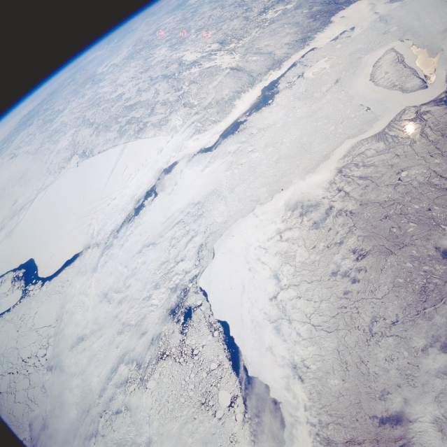 |
| STS039-602-055 Hudson, James Bays, Canada May 1991 The southern end of Hudson Bay (lower left) and its southern extension James Bay (upper right), are visible in this southeast-looking view. Cloud cover partially obscures the different sized ice floes that can be found mainly in the south central section of Hudson Bay. The large, white, smooth-looking features east and west of the water are probably snow covered ice that are adjacent to the shorelines of Quebec (top) and Ontario (bottom). The dark areas within Hudson and James Bays show the extent of open water in spring (May). Akimiski Island is the island near the western side of James Bay (upper right corner). |
| Images: | All Available Images Low-Resolution 305k |
|
| Mission: | STS039 |
|
| Roll - Frame: | 602 - 55 |
|
| Geographical Name: | CANADA-Q |
|
| Features: | JAMES BAY, ICE FLOWS |
|
| Center Lat x Lon: | 54.0N x 79W |
|
| Film Exposure: | U | N=Normal exposure, U=Under exposed, O=Over exposed, F=out of Focus |
| Percentage of Cloud Cover-CLDP: | 20 |
|
| Camera:: | RX |
|
| Camera Tilt: | HO | LO=Low Oblique, HO=High Oblique, NV=Near Vertical |
| Camera Focal Length: | 100 |
|
| Nadir to Photo Center Direction: | E | The direction from the nadir to the center point, N=North, S=South, E=East, W=West |
| Stereo?: | N | Y=Yes there is an adjacent picture of the same area, N=No there isn't |
| Orbit Number: | 19 |
|
| Date: | 19910429 | YYYYMMDD |
| Time: | 144100 | GMT HHMMSS |
| Nadir Lat: | 53.9N |
Latitude of suborbital point of spacecraft |
| Nadir Lon: | 91.1W |
Longitude of suborbital point of spacecraft |
| Sun Azimuth: | 115 | Clockwise angle in degrees from north to the sun measured at the nadir point |
| Space Craft Altitude: | 138 | nautical miles |
| Sun Elevation: | 35 | Angle in degrees between the horizon and the sun, measured at the nadir point |
| Land Views: | ISLAND |
|
| Water Views: | SEA ICE, BAY |
|
| Atmosphere Views: | |
|
| Man Made Views: | |
|
| City Views: | |
|
Photo is not associated with any sequences | ||
| NASA Home Page |
JSC Home Page |
JSC Digital Image Collection |
Earth Science & Remote Sensing |
|
This service is provided by the International Space Station program and the JSC Earth Science & Remote Sensing Unit, ARES Division, Exploration Integration Science Directorate.

|