
Geographic Region: USA-NEVADA
Feature: MONO AND WALKER LAKES
|
Geographic Region: USA-NEVADA Feature: MONO AND WALKER LAKES |
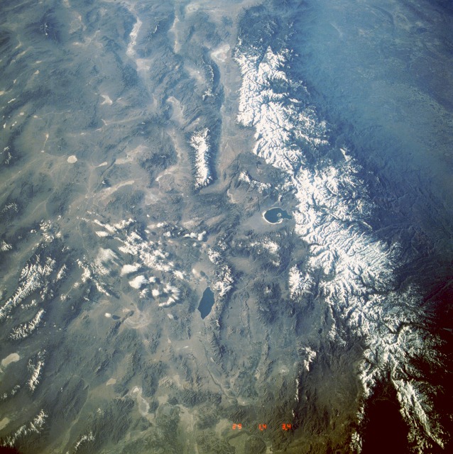 |
| STS039-602-046 Sierra Nevada and Great Basin, California and Nevada, U.S.A. May 1991 The snow-covered Sierra Nevada, seen in this south-looking, low-oblique photograph, is the largest fault-block mountain range in the United States. Extending northwest-southeast, the mountain range, 400 miles (645 kilometers) long and 40 to 80 miles (65 to 130 kilometers) wide, rises sharply on its eastern side from the Great Basin, whereas its western slope descends gradually to the hills bordering the Central Valley of California (visible in the southwest corner of the photograph). Snow-fed streams supply irrigation water and generate hydroelectricity for the Central Valley and western Nevada. To the east of the Sierra Nevada, the western portions of the Great Basin can be seen. Aptly named because it sits between the Sierra Nevada to the west and the high Colorado Plateau and Wasatch Range to the east (not included in the photograph), the Great Basin comprises many smaller basins separated by fault-block mountain ranges rising 2000 to 3000 feet (600 to 900 meters) above the alluvium-filled floors of the basins. Three small bluish-colored lakes can be seen in the photograph. The southern portion of Lake Tahoe is barely discernible in the northwest corner of the photograph. East-southeast of Lake Tahoe is Walker Lake, and Mono Lake lies southeast of Lake Tahoe (near the center of the photograph). |
| Images: | All Available Images Low-Resolution 160k |
|
| Mission: | STS039 |
|
| Roll - Frame: | 602 - 46 |
|
| Geographical Name: | USA-NEVADA |
|
| Features: | MONO AND WALKER LAKES |
|
| Center Lat x Lon: | 38.5N x 118.5W |
|
| Film Exposure: | N | N=Normal exposure, U=Under exposed, O=Over exposed, F=out of Focus |
| Percentage of Cloud Cover-CLDP: | 5 |
|
| Camera:: | RX |
|
| Camera Tilt: | LO | LO=Low Oblique, HO=High Oblique, NV=Near Vertical |
| Camera Focal Length: | 100 |
|
| Nadir to Photo Center Direction: | E | The direction from the nadir to the center point, N=North, S=South, E=East, W=West |
| Stereo?: | N | Y=Yes there is an adjacent picture of the same area, N=No there isn't |
| Orbit Number: | 19 |
|
| Date: | 19910429 | YYYYMMDD |
| Time: | 143400 | GMT HHMMSS |
| Nadir Lat: | 37.1N |
Latitude of suborbital point of spacecraft |
| Nadir Lon: | 122.1W |
Longitude of suborbital point of spacecraft |
| Sun Azimuth: | 82 | Clockwise angle in degrees from north to the sun measured at the nadir point |
| Space Craft Altitude: | 139 | nautical miles |
| Sun Elevation: | 14 | Angle in degrees between the horizon and the sun, measured at the nadir point |
| Land Views: | MOUNTAIN, VALLEY, HILL |
|
| Water Views: | LAKE |
|
| Atmosphere Views: | |
|
| Man Made Views: | |
|
| City Views: | |
|
Photo is not associated with any sequences | ||
| NASA Home Page |
JSC Home Page |
JSC Digital Image Collection |
Earth Science & Remote Sensing |
|
This service is provided by the International Space Station program and the JSC Earth Science & Remote Sensing Unit, ARES Division, Exploration Integration Science Directorate.

|