
Geographic Region: CANADA-N
Feature: JET STREAM, ICE FLOWS
|
Geographic Region: CANADA-N Feature: JET STREAM, ICE FLOWS |
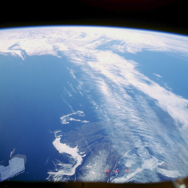 |
| STS039-601-049 Jet Stream, Maritime Provinces, Canada May 1991 The Northern Hemisphere Jet Stream can be seen crossing Cape Breton Island in the Maritime Provinces of Eastern Canada. The Jet Stream is a narrow zone of high-speed winds typically found at altitudes of 4 to 8 miles (8-12 km) above the earth. They result from temperature contrasts between polar and tropical regions. The strongest Jet Stream winds are found in the winter when the contrast between polar and tropical regions is the greatest. Wind speeds can reach 90 to over 180 miles per hour (145 to over 290 km/h) from west to east. Jet Streams are found between latitudes 20 to near 55 north and south. During the winter months over the United States and southern Canada, the path taken by the Jet Stream can have a large influence on the weather conditions of this region. |
| Images: | All Available Images Low-Resolution 93k |
|
| Mission: | STS039 |
|
| Roll - Frame: | 601 - 49 |
|
| Geographical Name: | CANADA-N |
|
| Features: | JET STREAM, ICE FLOWS |
|
| Center Lat x Lon: | N x E |
|
| Film Exposure: | N | N=Normal exposure, U=Under exposed, O=Over exposed, F=out of Focus |
| Percentage of Cloud Cover-CLDP: | 50 |
|
| Camera:: | RX |
|
| Camera Tilt: | HO | LO=Low Oblique, HO=High Oblique, NV=Near Vertical |
| Camera Focal Length: | 100 |
|
| Nadir to Photo Center Direction: | The direction from the nadir to the center point, N=North, S=South, E=East, W=West |
|
| Stereo?: | N | Y=Yes there is an adjacent picture of the same area, N=No there isn't |
| Orbit Number: | 17 |
|
| Date: | 19910429 | YYYYMMDD |
| Time: | 113900 | GMT HHMMSS |
| Nadir Lat: | 48.4N |
Latitude of suborbital point of spacecraft |
| Nadir Lon: | 60.4W |
Longitude of suborbital point of spacecraft |
| Sun Azimuth: | 99 | Clockwise angle in degrees from north to the sun measured at the nadir point |
| Space Craft Altitude: | 138 | nautical miles |
| Sun Elevation: | 27 | Angle in degrees between the horizon and the sun, measured at the nadir point |
| Land Views: | |
|
| Water Views: | |
|
| Atmosphere Views: | JET STREAM |
|
| Man Made Views: | |
|
| City Views: | |
|
Photo is not associated with any sequences | ||
| NASA Home Page |
JSC Home Page |
JSC Digital Image Collection |
Earth Science & Remote Sensing |
|
This service is provided by the International Space Station program and the JSC Earth Science & Remote Sensing Unit, ARES Division, Exploration Integration Science Directorate.

|