Geographic Region: SPAIN
Feature: STRAIT OF GIBRALTAR
|
Geographic Region: SPAIN Feature: STRAIT OF GIBRALTAR |
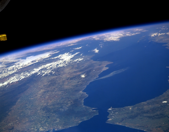 |
| STS039-151-193A Strait of Gibraltar, Spain/Morocco May 1991 The Strait of Gibraltar (bottom center), the only opening between the Mediterranean Sea (right center) and the Atlantic Ocean, is not only narrow (10 miles-16 km) in width but shallow (1300 feet-396 meters) as well. The northern peninsula of Morocco (lower right) extends northward towards the southwest coast of Spain. The strait locates where the two tectonic plates of Eurasian (north) and Africa (south) collide. Immediately east of the strait is the Alboran Sea (western extension of the Mediterranean Sea), a name given to the body of water between Spain and Morocco. A single atmospheric cloud (light-colored feature), probably smoke, is visible over the Alboran Sea as it extends southward from the south central coast of Spain. The darker landscapes in Morocco and Spain show the location of the vegetated, mountainous regions. The snow covered, higher elevations (maximum elevation 11421 feet-3481 meters) of the Sierra Nevada (Spain) are also visible near the center of the image. An extensive plains region (lighter-colored land corridor in lower left quadrant of image), known as the Andalusian Plains extends southward from the Guadalquivir River Valley. An abrupt color change near the lower left margin of the image is the result of an extensive, east-west trending fault that forms the northern boundary of the Guadalquivr River Valley. |
| Images: | All Available Images Low-Resolution 183k |
|
| Mission: | STS039 |
|
| Roll - Frame: | 151 - 193 A |
|
| Geographical Name: | SPAIN |
|
| Features: | STRAIT OF GIBRALTAR |
|
| Center Lat x Lon: | 37.0N x 3W |
|
| Film Exposure: | N | N=Normal exposure, U=Under exposed, O=Over exposed, F=out of Focus |
| Percentage of Cloud Cover-CLDP: | 20 |
|
| Camera:: | LH |
|
| Camera Tilt: | HO | LO=Low Oblique, HO=High Oblique, NV=Near Vertical |
| Camera Focal Length: | 250 |
|
| Nadir to Photo Center Direction: | E | The direction from the nadir to the center point, N=North, S=South, E=East, W=West |
| Stereo?: | N | Y=Yes there is an adjacent picture of the same area, N=No there isn't |
| Orbit Number: | 52 |
|
| Date: | 19910501 | YYYYMMDD |
| Time: | 144234 | GMT HHMMSS |
| Nadir Lat: | 33.7N |
Latitude of suborbital point of spacecraft |
| Nadir Lon: | 10.7W |
Longitude of suborbital point of spacecraft |
| Sun Azimuth: | 231 | Clockwise angle in degrees from north to the sun measured at the nadir point |
| Space Craft Altitude: | 139 | nautical miles |
| Sun Elevation: | 57 | Angle in degrees between the horizon and the sun, measured at the nadir point |
| Land Views: | MOUNTAIN |
|
| Water Views: | STRAIT, SEA |
|
| Atmosphere Views: | |
|
| Man Made Views: | |
|
| City Views: | |
|
Photo is not associated with any sequences | ||
| NASA Home Page |
JSC Home Page |
JSC Digital Image Collection |
Earth Science & Remote Sensing |
|
This service is provided by the International Space Station program and the JSC Earth Science & Remote Sensing Unit, ARES Division, Exploration Integration Science Directorate.

|