
Geographic Region: USA-CALIFORNIA
Feature: LOS ANGELES BASIN AREA
|
Geographic Region: USA-CALIFORNIA Feature: LOS ANGELES BASIN AREA |
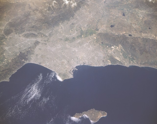 |
| STS039-151-184 Los Angeles Basin, California, U.S.A. May 1991 The Los Angeles metropolitan area includes five counties and covers 34 000 square miles (88 060 square kilometers). Nearly 10 million people live and work in this dynamic region. Los Angeles is important economically because of shipping, industrial facilities, distribution centers, and financial institutions. Not many individual highways are clearly visible in this photograph; however, the alignment of some major thoroughfares can be observed by looking at the clustered light areas. These clustered, highly reflective areas show concentrations of industrial and commercial activities within the urban area. Several major physical features are seen in this photograph, including the Santa Monica Mountains (northwest), the San Gabriel Mountains (northeast), the Puente Hills (east), and the Santa Ana Mountains (southeast). Along the coast, Palos Verdes is a rolling, hilly promontory in the Pacific Ocean. Even on this scale, there is evidence that a large harbor and port exist in the San Pedro and Long Beach areas southeast of Palos Verdes. The three large lakes east-southeast of the heavily populated area are reservoirs. Also in the photograph is the resort island of Santa Catalina, which is approximately 20 miles (30 kilometers) west of the California coast. (Refer to STS-039-089-062 for a color infrared photograph that shows the same general area.) This rare cloud and smog free view of Los Angeles, CA (34.0N, 118.5W) is a result of strong Santa Ana winds blowing from the east. Both cultural and natural features are well displayed and all of the major streets, highways and freeways can be traced in their entirety throughout the city as well as the major business and commercial sections. On the eastern edge of the scene, the San Andreas fault cuts across from southeast to northwest. |
| Images: | All Available Images Low-Resolution 77k |
|
| Mission: | STS039 |
|
| Roll - Frame: | 151 - 184 |
|
| Geographical Name: | USA-CALIFORNIA |
|
| Features: | LOS ANGELES BASIN AREA |
|
| Center Lat x Lon: | 34.0N x 118.5W |
|
| Film Exposure: | N | N=Normal exposure, U=Under exposed, O=Over exposed, F=out of Focus |
| Percentage of Cloud Cover-CLDP: | 5 |
|
| Camera:: | LH |
|
| Camera Tilt: | 37 | LO=Low Oblique, HO=High Oblique, NV=Near Vertical |
| Camera Focal Length: | 250 |
|
| Nadir to Photo Center Direction: | NE | The direction from the nadir to the center point, N=North, S=South, E=East, W=West |
| Stereo?: | N | Y=Yes there is an adjacent picture of the same area, N=No there isn't |
| Orbit Number: | 41 |
|
| Date: | 19910430 | YYYYMMDD |
| Time: | 221800 | GMT HHMMSS |
| Nadir Lat: | 33.1N |
Latitude of suborbital point of spacecraft |
| Nadir Lon: | 120W |
Longitude of suborbital point of spacecraft |
| Sun Azimuth: | 243 | Clockwise angle in degrees from north to the sun measured at the nadir point |
| Space Craft Altitude: | 139 | nautical miles |
| Sun Elevation: | 54 | Angle in degrees between the horizon and the sun, measured at the nadir point |
| Land Views: | BASIN, COAST, FOREST, HILL, ISLAND, MOUNTAIN, VALLEY |
|
| Water Views: | BAY, OCEAN, RESERVOIR |
|
| Atmosphere Views: | |
|
| Man Made Views: | URBAN AREA |
|
| City Views: | LOS ANGELES |
|
Photo is not associated with any sequences | ||
| NASA Home Page |
JSC Home Page |
JSC Digital Image Collection |
Earth Science & Remote Sensing |
|
This service is provided by the International Space Station program and the JSC Earth Science & Remote Sensing Unit, ARES Division, Exploration Integration Science Directorate.

|