
Geographic Region: USA-TEXAS
Feature: HOUSTON-GALVESTON AREA
|
Geographic Region: USA-TEXAS Feature: HOUSTON-GALVESTON AREA |
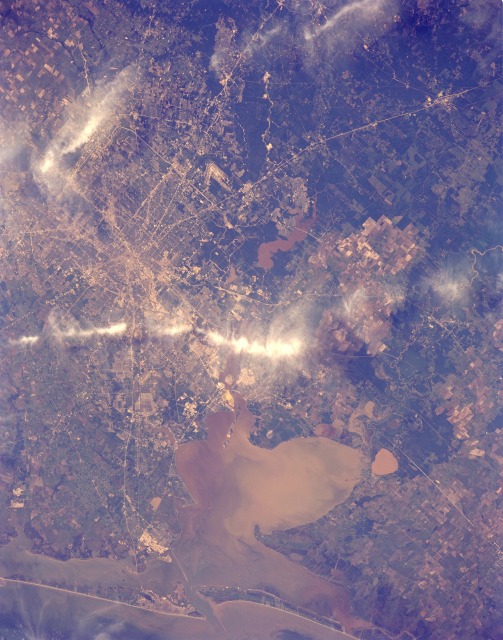 |
| STS039-151-175 Houston, Texas, U.S.A. May 1991 Although two bands of clouds obscure part of this near-vertical photograph of metropolitan Houston, much urban infrastructure can be identified, such as Lake Houston (northeast of downtown), the source of most of the city's drinking water. Numerous major highways converge on the downtown central business district, and two beltways (the inner loop--Interstate Highway 610, and the outer loop--partially constructed Beltway 8) encircle the city. Highly reflective areas of concrete and metals indicate concentrations of industrial and commercial activities. One such corridor extending eastward to Galveston Bay from near downtown is the Houston Ship Channel, home to many chemical plants and oil refineries. Just north of the causeway linking Galveston Island with the mainland is Texas City, a major site for oil refining and chemical processing. Houston has three main airports--large, V-shaped Houston Intercontinental Airport (visible north of downtown), Ellington Field (visible southeast of downtown), and Hobby Airport (obscured by cloud cover southeast of downtown). Residential street patterns are discernible in many of the surrounding communities. NASA Lyndon B. Johnson Space Center is east of Interstate Highway 45 immediately northeast of Clear Lake. East of Houston cultivated fields of rice flank the Trinity River. Lake Anahuac is the small brown, roughly circular body of water just south of Interstate Highway 10. This photograph provides a visual record of the sediment characteristics and turbidity of Galveston Bay. In this view of Houston/Galveston, Texas, USA (29.5N, 95.5W), heavy spring rains emphasize the several bodies of water in the area. The progressive nature of the Houston highway and freeway system can easily be observed in this highly detailed view. Houston Intercontiental Airport can be seen to the north and to the south, the NASA, Clear Lake area just off of Galveston Bay can easily be seen. In the center, is the downtown business district. |
| Images: | All Available Images Low-Resolution 122k |
|
| Mission: | STS039 |
|
| Roll - Frame: | 151 - 175 |
|
| Geographical Name: | USA-TEXAS |
|
| Features: | HOUSTON-GALVESTON AREA |
|
| Center Lat x Lon: | 29.5N x 95.5W |
|
| Film Exposure: | N | N=Normal exposure, U=Under exposed, O=Over exposed, F=out of Focus |
| Percentage of Cloud Cover-CLDP: | 5 |
|
| Camera:: | LH |
|
| Camera Tilt: | 26 | LO=Low Oblique, HO=High Oblique, NV=Near Vertical |
| Camera Focal Length: | 250 |
|
| Nadir to Photo Center Direction: | SW | The direction from the nadir to the center point, N=North, S=South, E=East, W=West |
| Stereo?: | Y | Y=Yes there is an adjacent picture of the same area, N=No there isn't |
| Orbit Number: | 40 |
|
| Date: | 19910430 | YYYYMMDD |
| Time: | 204920 | GMT HHMMSS |
| Nadir Lat: | 30.4N |
Latitude of suborbital point of spacecraft |
| Nadir Lon: | 94.8W |
Longitude of suborbital point of spacecraft |
| Sun Azimuth: | 250 | Clockwise angle in degrees from north to the sun measured at the nadir point |
| Space Craft Altitude: | 139 | nautical miles |
| Sun Elevation: | 52 | Angle in degrees between the horizon and the sun, measured at the nadir point |
| Land Views: | COAST, PLAIN, ISLAND |
|
| Water Views: | GULF, BAY, SEDIMENT, CHANNEL |
|
| Atmosphere Views: | |
|
| Man Made Views: | URBAN AREA, AGRICULTURE |
|
| City Views: | HOUSTON, GALVESTON |
|
Photo is not associated with any sequences | ||
| NASA Home Page |
JSC Home Page |
JSC Digital Image Collection |
Earth Science & Remote Sensing |
|
This service is provided by the International Space Station program and the JSC Earth Science & Remote Sensing Unit, ARES Division, Exploration Integration Science Directorate.

|