
Geographic Region: USA-TEXAS
Feature: DALLAS-FORT WORTH AREA
|
Geographic Region: USA-TEXAS Feature: DALLAS-FORT WORTH AREA |
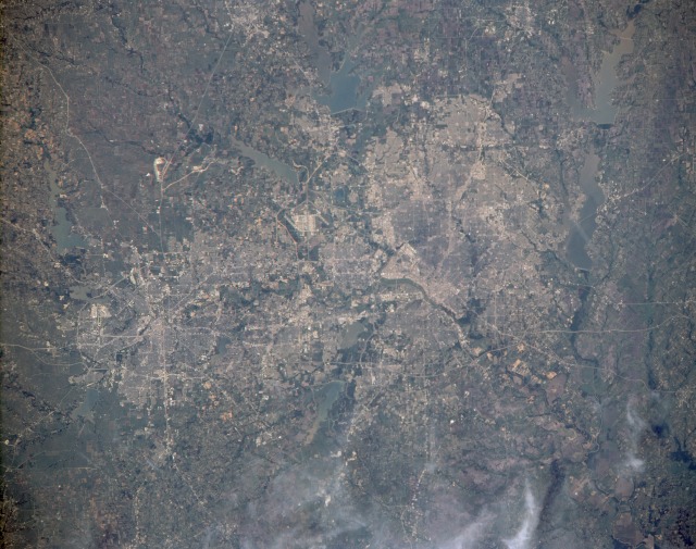 |
| STS039-151-172 Dallas-Fort Worth Metroplex, Texas, U.S.A. April 1991 The sprawling Dallas-Fort Worth metroplex is shown in this near-vertical photograph. Near the center of the photograph, situated between Dallas to the east and Fort Worth to the west, is Dallas-Fort Worth International Airport (DFW), one of the largest commercial airports in the world. The communities between Dallas and Fort Worth, which are 33 miles (53 kilometers) apart, have grown rapidly since the 1970s, adding to the metroplex's standing as a leading commercial, financial, transportation, agricultural, and oil-producing center in the southwest United States. Many interstate highways can be seen running in all directions throughout the metroplex. Agricultural field patterns and numerous lakes and reservoirs fringe the metroplex. Clockwise from Lewisville Reservoir at "noon," the lakes visible in the photograph include Lake Ray Hubbard (just east of Dallas), Lake Lavon (northeast of Dallas), Lewisville Reservoir (northwest of Dallas), Grapevine Reservoir (just north of DFW), Eagle Mountain Lake (northwest of Fort Worth), Lake Worth (just north of Carswell Air Force Base in Fort Worth), Benbrook Lake (southwest of Fort Worth), Lake Arlington (southeast of Fort Worth), Mountain Creek Lake (southwest edge of Dallas), and Joe Pool Lake (an elongated lake just south of Mountain Creek Lake). In this best ever view of Dallas and Ft. Worth, Texas, USA (32.5N, 97.0W) the detail is good enough to use as a road map of the major highways throughout the area. The new Dallas/Ft. Worth International Airport is near the center of the scene. Almost twenty lakes and reservoirs in the area, reflecting the recent heavy spring rainfall, by their high water levels, are easily delineated in the view. |
| Images: | All Available Images Low-Resolution 123k |
|
| Mission: | STS039 |
|
| Roll - Frame: | 151 - 172 |
|
| Geographical Name: | USA-TEXAS |
|
| Features: | DALLAS-FORT WORTH AREA |
|
| Center Lat x Lon: | 32.5N x 97W |
|
| Film Exposure: | N | N=Normal exposure, U=Under exposed, O=Over exposed, F=out of Focus |
| Percentage of Cloud Cover-CLDP: | 5 |
|
| Camera:: | LH |
|
| Camera Tilt: | 18 | LO=Low Oblique, HO=High Oblique, NV=Near Vertical |
| Camera Focal Length: | 250 |
|
| Nadir to Photo Center Direction: | S | The direction from the nadir to the center point, N=North, S=South, E=East, W=West |
| Stereo?: | N | Y=Yes there is an adjacent picture of the same area, N=No there isn't |
| Orbit Number: | 40 |
|
| Date: | 19910430 | YYYYMMDD |
| Time: | 204827 | GMT HHMMSS |
| Nadir Lat: | 33.2N |
Latitude of suborbital point of spacecraft |
| Nadir Lon: | 97.3W |
Longitude of suborbital point of spacecraft |
| Sun Azimuth: | 244 | Clockwise angle in degrees from north to the sun measured at the nadir point |
| Space Craft Altitude: | 139 | nautical miles |
| Sun Elevation: | 53 | Angle in degrees between the horizon and the sun, measured at the nadir point |
| Land Views: | PLAIN |
|
| Water Views: | RIVER, LAKE, RESERVOIR |
|
| Atmosphere Views: | |
|
| Man Made Views: | URBAN AREA, AGRICULTURE, DAM, AIRPORT |
|
| City Views: | DALLAS, FORT WORTH |
|
Photo is not associated with any sequences | ||
| NASA Home Page |
JSC Home Page |
JSC Digital Image Collection |
Earth Science & Remote Sensing |
|
This service is provided by the International Space Station program and the JSC Earth Science & Remote Sensing Unit, ARES Division, Exploration Integration Science Directorate.

|