Geographic Region: TANZANIA
Feature: MT. KILIMANJARO SUMMIT
|
Geographic Region: TANZANIA Feature: MT. KILIMANJARO SUMMIT |
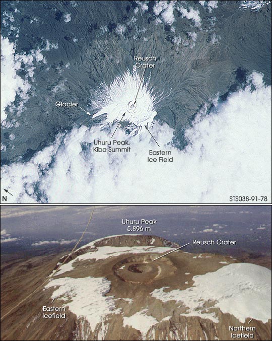 |
| Ten years ago, glaciers covered most of the summit of Mt. Kilimanjaro. This photograph was taken in November 1990 by the Space Shuttle mission STS-38 crew. By 2001, the glaciers had receded alarmingly, as shown by another photograph of Kilimanjaro taken by the crew of Space Shuttle mission STS-97 on December 2, 2000 Mountain glaciers are sensitive indicators of climate change, and those at tropical latitudes are particularly responsive. Mid-latitude and tropical glaciers have significantly decreased in area and volume over the past century. At the February 2001 meeting of the American Association for the Advancement of Science (AAAS), researchers reported dramatic changes in the volume of ice capping the Kibo summit of Kilimanjaro. An estimated 82 percent of the icecap that crowned the mountain when it was first thoroughly surveyed in 1912 is now gone, and the ice is thinning as well -- by as much as a meter in one area. According to some projections, if recession continues at the present rate, the majority of the glaciers on Kilimanjaro could vanish in the next 15 years. Aerial photograph copyright Alan Root, published in: Hastenrath, S., 1984, The Glaciers of Equatorial East Africa: D. Reidel Publishing Co., 353 p. |
| Images: | All Available Images Low-Resolution 89k |
|
| Mission: | STS038 |
|
| Roll - Frame: | 91 - 78 |
|
| Geographical Name: | TANZANIA |
|
| Features: | MT. KILIMANJARO SUMMIT |
|
| Center Lat x Lon: | 3S x 37.5E |
|
| Film Exposure: | N | N=Normal exposure, U=Under exposed, O=Over exposed, F=out of Focus |
| Percentage of Cloud Cover-CLDP: | 60 |
|
| Camera:: | HB |
|
| Camera Tilt: | 29 | LO=Low Oblique, HO=High Oblique, NV=Near Vertical |
| Camera Focal Length: | 250 |
|
| Nadir to Photo Center Direction: | S | The direction from the nadir to the center point, N=North, S=South, E=East, W=West |
| Stereo?: | Y | Y=Yes there is an adjacent picture of the same area, N=No there isn't |
| Orbit Number: | 54 |
|
| Date: | 19901119 | YYYYMMDD |
| Time: | 075709 | GMT HHMMSS |
| Nadir Lat: | 1.8S |
Latitude of suborbital point of spacecraft |
| Nadir Lon: | 37.5E |
Longitude of suborbital point of spacecraft |
| Sun Azimuth: | 134 | Clockwise angle in degrees from north to the sun measured at the nadir point |
| Space Craft Altitude: | 128 | nautical miles |
| Sun Elevation: | 64 | Angle in degrees between the horizon and the sun, measured at the nadir point |
| Land Views: | MOUNTAIN,GLACIER |
|
| Water Views: | ICE |
|
| Atmosphere Views: | |
|
| Man Made Views: | |
|
| City Views: | |
|
Photo is not associated with any sequences | ||
| NASA Home Page |
JSC Home Page |
JSC Digital Image Collection |
Earth Science & Remote Sensing |
|
This service is provided by the International Space Station program and the JSC Earth Science & Remote Sensing Unit, ARES Division, Exploration Integration Science Directorate.

|