
Geographic Region: MEXICO
Feature: TORREON,GOMEZ PAL ACIO
|
Geographic Region: MEXICO Feature: TORREON,GOMEZ PAL ACIO |
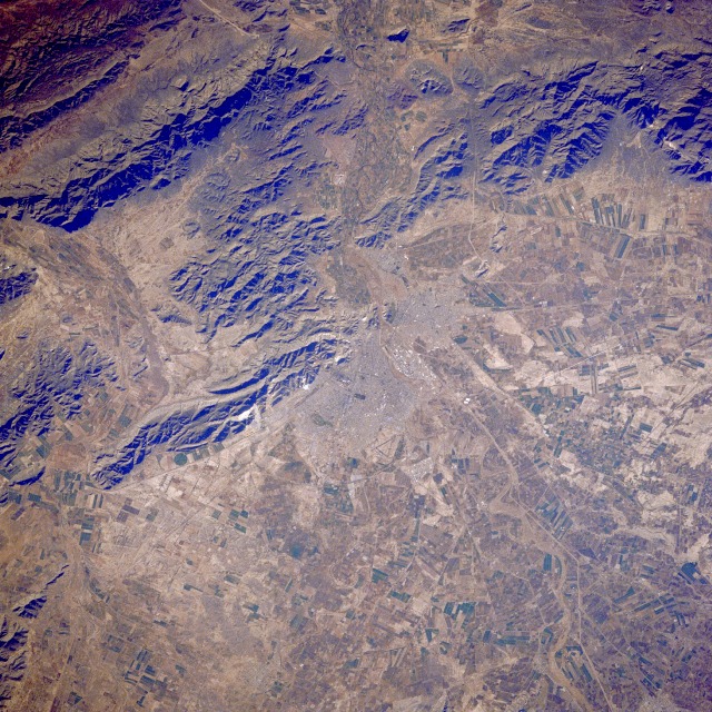 |
| STS038-086-006 Torreoón, Mexico November 1990 Torreoón, with an estimated population of 250 000, is located on the arid-to-semiarid plateau of north-central Mexico approximately 150 miles (240 kilometers) west of Monterrey. The Torreoón metropolitan area includes the smaller cities of Gómez Palacio and Lerdo, which cluster at the mouth of the Nazas River, parts of which are seen northeast and southwest of the urban area. Visible are several infrastructure features--the airport northeast of Torreoón; several roads and railroads; the more highly reflective commercial and industrial section of Torreoón; and a grid street pattern. Outside the urban area, cultivated agricultural fields abound; cotton and wheat are the two main crops grown in the region. During the mid-1900s, this basin was a major cotton-growing area of Mexico. Large mechanized, irrigated farms were developed by tapping into the once-abundant deep wells for ground water; however, in recent decades, farmers have depended on more meager supplies of surface water for irrigation. This region generally receives less than 20 inches (50 centimeters) of precipitation annually. Torreoón is a major railroad center, especially for north-south traffic through Mexico. |
| Images: | All Available Images Low-Resolution 203k |
|
| Mission: | STS038 |
|
| Roll - Frame: | 86 - 6 |
|
| Geographical Name: | MEXICO |
|
| Features: | TORREON,GOMEZ PAL ACIO |
|
| Center Lat x Lon: | 25.5N x 103.5W |
|
| Film Exposure: | N | N=Normal exposure, U=Under exposed, O=Over exposed, F=out of Focus |
| Percentage of Cloud Cover-CLDP: | 0 |
|
| Camera:: | HB |
|
| Camera Tilt: | 14 | LO=Low Oblique, HO=High Oblique, NV=Near Vertical |
| Camera Focal Length: | 250 |
|
| Nadir to Photo Center Direction: | NE | The direction from the nadir to the center point, N=North, S=South, E=East, W=West |
| Stereo?: | N | Y=Yes there is an adjacent picture of the same area, N=No there isn't |
| Orbit Number: | 48 |
|
| Date: | 19901118 | YYYYMMDD |
| Time: | 214943 | GMT HHMMSS |
| Nadir Lat: | 25.2N |
Latitude of suborbital point of spacecraft |
| Nadir Lon: | 103.9W |
Longitude of suborbital point of spacecraft |
| Sun Azimuth: | 230 | Clockwise angle in degrees from north to the sun measured at the nadir point |
| Space Craft Altitude: | 116 | nautical miles |
| Sun Elevation: | 26 | Angle in degrees between the horizon and the sun, measured at the nadir point |
| Land Views: | MOUNTAIN, VALLEY, PLATEAU |
|
| Water Views: | RIVER |
|
| Atmosphere Views: | |
|
| Man Made Views: | URBAN AREA, AIRPORT, AGRICULTURE |
|
| City Views: | |
|
Photo is not associated with any sequences | ||
| NASA Home Page |
JSC Home Page |
JSC Digital Image Collection |
Earth Science & Remote Sensing |
|
This service is provided by the International Space Station program and the JSC Earth Science & Remote Sensing Unit, ARES Division, Exploration Integration Science Directorate.

|