
Geographic Region: USA-TEXAS
Feature: CORPUS CHRISTI, COAST
|
Geographic Region: USA-TEXAS Feature: CORPUS CHRISTI, COAST |
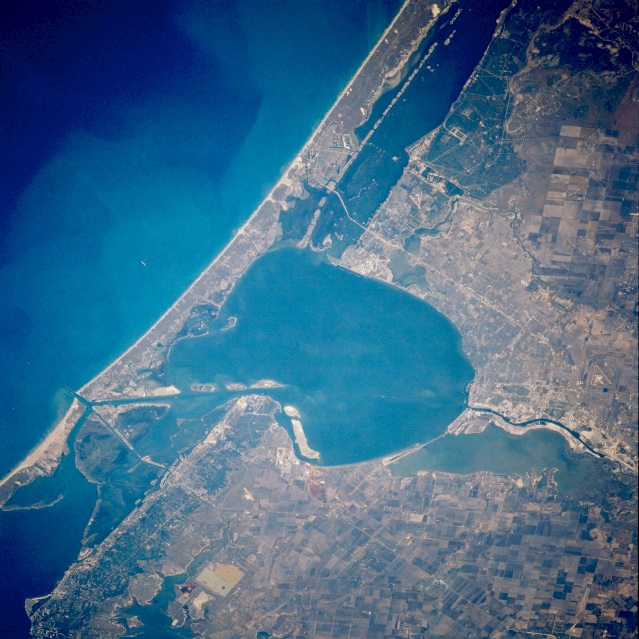 |
| STS038-086-016 Corpus Christi Bay, Texas, U.S.A. November 1990 Roughly oval Corpus Christi Bay and Mustang Island, part of the sandy barrier islands that separate this bay from the Gulf of Mexico, are featured in this photograph. The dark lagoon paralleling the coastline south of Corpus Christi Bay is the northern extent of Laguna Madre; Aransas Bay lies inland north of Corpus Christi Bay (lower left corner). Corpus Christi Bay connects with the Gulf of Mexico via Aransas Pass, a dredged ship canal, the material from which created the islands along the northern edge of the bay. Lighter Nueces Bay is visible west of Corpus Christi Bay. Part of the Intracoastal Waterway can be traced through Aransas Bay, Corpus Christi Bay, and Laguna Madre. Apparent are some street patterns within Corpus Christi along the southwest coast of Corpus Christi Bay; a vegetated swath of live oaks that parallels the coast to the north; Live Oak Ridge, a ridge of stabilized sand dunes; and angular agricultural field patterns north and southwest of Corpus Christi. |
| Images: | All Available Images Low-Resolution 361k |
|
| Mission: | STS038 |
|
| Roll - Frame: | 86 - 16 |
|
| Geographical Name: | USA-TEXAS |
|
| Features: | CORPUS CHRISTI, COAST |
|
| Center Lat x Lon: | 28.0N x 97.5W |
|
| Film Exposure: | N | N=Normal exposure, U=Under exposed, O=Over exposed, F=out of Focus |
| Percentage of Cloud Cover-CLDP: | 0 |
|
| Camera:: | HB |
|
| Camera Tilt: | 37 | LO=Low Oblique, HO=High Oblique, NV=Near Vertical |
| Camera Focal Length: | 250 |
|
| Nadir to Photo Center Direction: | N | The direction from the nadir to the center point, N=North, S=South, E=East, W=West |
| Stereo?: | N | Y=Yes there is an adjacent picture of the same area, N=No there isn't |
| Orbit Number: | 48 |
|
| Date: | 19901118 | YYYYMMDD |
| Time: | 215122 | GMT HHMMSS |
| Nadir Lat: | 26.6N |
Latitude of suborbital point of spacecraft |
| Nadir Lon: | 97.1W |
Longitude of suborbital point of spacecraft |
| Sun Azimuth: | 235 | Clockwise angle in degrees from north to the sun measured at the nadir point |
| Space Craft Altitude: | 116 | nautical miles |
| Sun Elevation: | 20 | Angle in degrees between the horizon and the sun, measured at the nadir point |
| Land Views: | COAST, PLAIN |
|
| Water Views: | BAY, LAGOON, GULF |
|
| Atmosphere Views: | |
|
| Man Made Views: | URBAN AREA, HIGHWAY, AIRPORT |
|
| City Views: | |
|
Photo is not associated with any sequences | ||
| NASA Home Page |
JSC Home Page |
JSC Digital Image Collection |
Earth Science & Remote Sensing |
|
This service is provided by the International Space Station program and the JSC Earth Science & Remote Sensing Unit, ARES Division, Exploration Integration Science Directorate.

|