
Geographic Region: USA-TEXAS
Feature: BROWNSVILLE SHIP CHANNEL, SEDIMENT
|
Geographic Region: USA-TEXAS Feature: BROWNSVILLE SHIP CHANNEL, SEDIMENT |
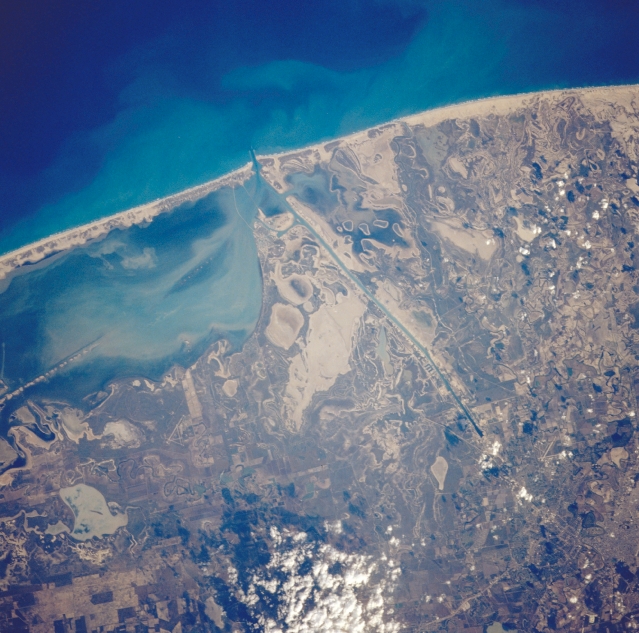 |
| STS038-86-15 South Coastal Texas, U.S.A. November 1990 Several features are identifiable in this photograph of the southern tip of coastal Texas--the southern end of South Padre Island; the southern end of Laguna Madre; the southern terminus of the Intracoastal Waterway; and the Brownsville Ship Channel. The coast adjacent to the Gulf of Mexico consists generally of a mixture of light sandy soils and rich brown soils that overlay the clays and sands of the Rio Grande floodplain. The mottled appearance of the landscape, showing an assortment of tidal flats, swampy areas, and sandy terrain, makes it impossible to discriminate where the Rio Grande "flows" through this broad delta. The sediment pattern in Laguna Madre and a portion of the dredged Intracoastal Waterway (left center) indicate that sandy soils are transported by air and water throughout the coastal region of South Padre Island. Only a single runway of the airport east of Brownsville is discernible (right bottom corner). |
| Images: | All Available Images Low-Resolution 348k |
|
| Mission: | STS038 |
|
| Roll - Frame: | 86 - 15 |
|
| Geographical Name: | USA-TEXAS |
|
| Features: | BROWNSVILLE SHIP CHANNEL, SEDIMENT |
|
| Center Lat x Lon: | 26.0N x 97.5W |
|
| Film Exposure: | N | N=Normal exposure, U=Under exposed, O=Over exposed, F=out of Focus |
| Percentage of Cloud Cover-CLDP: | 5 |
|
| Camera:: | HB |
|
| Camera Tilt: | 17 | LO=Low Oblique, HO=High Oblique, NV=Near Vertical |
| Camera Focal Length: | 250 |
|
| Nadir to Photo Center Direction: | S | The direction from the nadir to the center point, N=North, S=South, E=East, W=West |
| Stereo?: | N | Y=Yes there is an adjacent picture of the same area, N=No there isn't |
| Orbit Number: | 48 |
|
| Date: | 19901118 | YYYYMMDD |
| Time: | 215116 | GMT HHMMSS |
| Nadir Lat: | 26.6N |
Latitude of suborbital point of spacecraft |
| Nadir Lon: | 97.5W |
Longitude of suborbital point of spacecraft |
| Sun Azimuth: | 235 | Clockwise angle in degrees from north to the sun measured at the nadir point |
| Space Craft Altitude: | 116 | nautical miles |
| Sun Elevation: | 20 | Angle in degrees between the horizon and the sun, measured at the nadir point |
| Land Views: | COAST, PLAIN |
|
| Water Views: | CHANNEL, LAGOON |
|
| Atmosphere Views: | |
|
| Man Made Views: | |
|
| City Views: | |
|
Photo is not associated with any sequences | ||
| NASA Home Page |
JSC Home Page |
JSC Digital Image Collection |
Earth Science & Remote Sensing |
|
This service is provided by the International Space Station program and the JSC Earth Science & Remote Sensing Unit, ARES Division, Exploration Integration Science Directorate.

|