
Geographic Region: USA-TEXAS
Feature: LAGUNA MADRE
|
Geographic Region: USA-TEXAS Feature: LAGUNA MADRE |
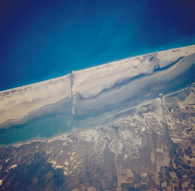 |
| STS038-86-14 Padre Island, Texas, U.S.A. November 1990 Featured in this photograph is a small section of Padre Island, an elongated, sandy barrier island in the Gulf of Mexico just north of Brownsville. This barrier island, which separates the Texas mainland from the Gulf of Mexico, creates Laguna Madre, a wide lagoon that produces a dynamic, ever-changing, sandy landscape. Pockets of sand dunes are apparent inland from the coast (bottom center). Two linear features are discernible--the Intracoastal Waterway between Padre Island and the mainland and an east-west-oriented dredged canal that cuts through the island. Cultivated field patterns are visible (lower right corner). Near-vertical view of southern Padre Island centered on the Mansfield Cut. Excellent depiction of sediment patterns in Laguna Madre, dune vegetation on Padre Island, eastern edge of the coastal dune field onshore. |
| Images: | All Available Images Low-Resolution 305k |
|
| Mission: | STS038 |
|
| Roll - Frame: | 86 - 14 |
|
| Geographical Name: | USA-TEXAS |
|
| Features: | LAGUNA MADRE |
|
| Center Lat x Lon: | 26.5N x 97W |
|
| Film Exposure: | N | N=Normal exposure, U=Under exposed, O=Over exposed, F=out of Focus |
| Percentage of Cloud Cover-CLDP: | 0 |
|
| Camera:: | HB |
|
| Camera Tilt: | 25 | LO=Low Oblique, HO=High Oblique, NV=Near Vertical |
| Camera Focal Length: | 250 |
|
| Nadir to Photo Center Direction: | E | The direction from the nadir to the center point, N=North, S=South, E=East, W=West |
| Stereo?: | N | Y=Yes there is an adjacent picture of the same area, N=No there isn't |
| Orbit Number: | 48 |
|
| Date: | 19901118 | YYYYMMDD |
| Time: | 215110 | GMT HHMMSS |
| Nadir Lat: | 26.5N |
Latitude of suborbital point of spacecraft |
| Nadir Lon: | 97.9W |
Longitude of suborbital point of spacecraft |
| Sun Azimuth: | 234 | Clockwise angle in degrees from north to the sun measured at the nadir point |
| Space Craft Altitude: | 116 | nautical miles |
| Sun Elevation: | 21 | Angle in degrees between the horizon and the sun, measured at the nadir point |
| Land Views: | COAST, PLAIN |
|
| Water Views: | CHANNEL, LAGOON |
|
| Atmosphere Views: | |
|
| Man Made Views: | AGRICULTURE |
|
| City Views: | |
|
Photo is not associated with any sequences | ||
| NASA Home Page |
JSC Home Page |
JSC Digital Image Collection |
Earth Science & Remote Sensing |
|
This service is provided by the International Space Station program and the JSC Earth Science & Remote Sensing Unit, ARES Division, Exploration Integration Science Directorate.

|