Geographic Region: CHAGOS ARCHIPELAGO
Feature: DIEGO GARCIA
|
Geographic Region: CHAGOS ARCHIPELAGO Feature: DIEGO GARCIA |
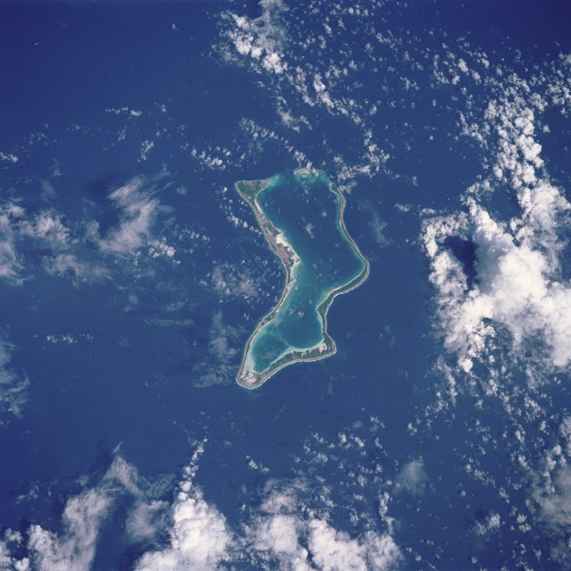 |
| STS038-086-104 Diego Garcia, Chagos Archipelago November 1990 The largest of the coral atolls of the Chagos Archipelago, Diego Garcia, is visible in this northwest-looking view. Diego Garcia is approximately 350 miles (560 km) south of the Maldive Islands in the central Indian Ocean. The crescent shape of the coral island encloses a lagoon that forms the harbor. Diego Garcia is the site of a large Anglo-American Naval Air and Communications facility located on the northwest part of the atoll. |
| Images: | All Available Images Low-Resolution 324k |
|
| Mission: | STS038 |
|
| Roll - Frame: | 86 - 104 |
|
| Geographical Name: | CHAGOS ARCHIPELAGO |
|
| Features: | DIEGO GARCIA |
|
| Center Lat x Lon: | 7.5S x 72.5E |
|
| Film Exposure: | N | N=Normal exposure, U=Under exposed, O=Over exposed, F=out of Focus |
| Percentage of Cloud Cover-CLDP: | 45 |
|
| Camera:: | HB |
|
| Camera Tilt: | 13 | LO=Low Oblique, HO=High Oblique, NV=Near Vertical |
| Camera Focal Length: | 250 |
|
| Nadir to Photo Center Direction: | N | The direction from the nadir to the center point, N=North, S=South, E=East, W=West |
| Stereo?: | Y | Y=Yes there is an adjacent picture of the same area, N=No there isn't |
| Orbit Number: | 52 |
|
| Date: | 19901119 | YYYYMMDD |
| Time: | 045547 | GMT HHMMSS |
| Nadir Lat: | 8S |
Latitude of suborbital point of spacecraft |
| Nadir Lon: | 72.4E |
Longitude of suborbital point of spacecraft |
| Sun Azimuth: | 115 | Clockwise angle in degrees from north to the sun measured at the nadir point |
| Space Craft Altitude: | 130 | nautical miles |
| Sun Elevation: | 59 | Angle in degrees between the horizon and the sun, measured at the nadir point |
| Land Views: | ATOLL |
|
| Water Views: | REEF, LAGOON |
|
| Atmosphere Views: | |
|
| Man Made Views: | |
|
| City Views: | |
|
Photo is not associated with any sequences | ||
| NASA Home Page |
JSC Home Page |
JSC Digital Image Collection |
Earth Science & Remote Sensing |
|
This service is provided by the International Space Station program and the JSC Earth Science & Remote Sensing Unit, ARES Division, Exploration Integration Science Directorate.

|