
Geographic Region: USA-FLORIDA
Feature: FLORIDA KEYS
|
Geographic Region: USA-FLORIDA Feature: FLORIDA KEYS |
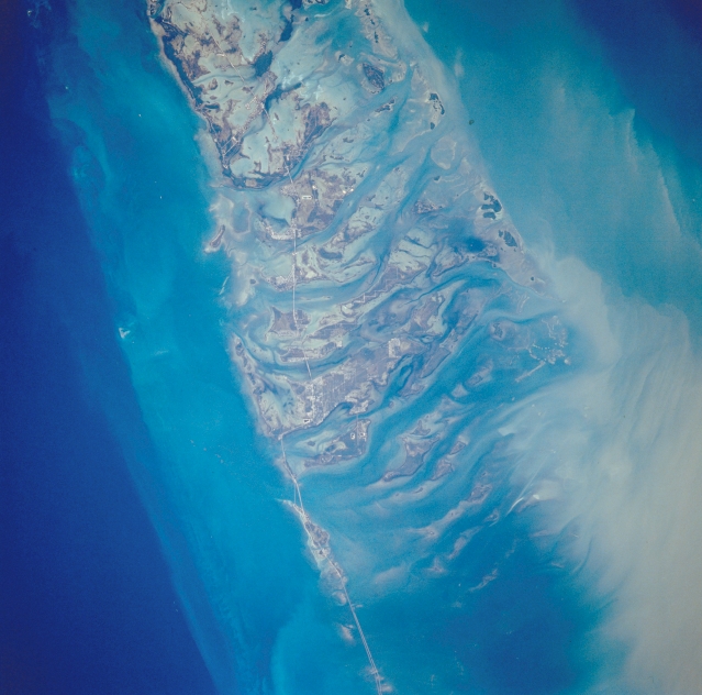 |
| STS-038-085-104 Florida Keys, Florida, U.S.A. November 1990 The Florida Keys, a line of narrow, low islands that begins at Key Largo extend in a gently curving, southwesterly arc along U. S. Highway 1 to Key West. Visible in this photograph are keys from Big Pine Key (near bottom center) to Sugarloaf Key (top center). Atlantic Ocean and Gulf of Mexico tides cut numerous channels through the coral and granular limestone sand (oolite) to create the islands (keys), which have thick growths of mangrove (darker areas) and many bays. The sediment plumes appear to be moving northwesterly into the Gulf of Mexico from the southeast (Atlantic Ocean). Because of the clarity of water throughout the region, water depth can be determined by different shades of blue--deeper water is darker and shallow water is lighter. In many instances these colors can represent differences in depth of tens to hundreds of feet (meters). |
| Images: | All Available Images Low-Resolution 289k |
|
| Mission: | STS038 |
|
| Roll - Frame: | 85 - 104 |
|
| Geographical Name: | USA-FLORIDA |
|
| Features: | FLORIDA KEYS |
|
| Center Lat x Lon: | 24.5N x 81.5W |
|
| Film Exposure: | N | N=Normal exposure, U=Under exposed, O=Over exposed, F=out of Focus |
| Percentage of Cloud Cover-CLDP: | 0 |
|
| Camera:: | HB |
|
| Camera Tilt: | 20 | LO=Low Oblique, HO=High Oblique, NV=Near Vertical |
| Camera Focal Length: | 250 |
|
| Nadir to Photo Center Direction: | SE | The direction from the nadir to the center point, N=North, S=South, E=East, W=West |
| Stereo?: | Y | Y=Yes there is an adjacent picture of the same area, N=No there isn't |
| Orbit Number: | 47 |
|
| Date: | 19901118 | YYYYMMDD |
| Time: | 202014 | GMT HHMMSS |
| Nadir Lat: | 25.0N |
Latitude of suborbital point of spacecraft |
| Nadir Lon: | 82W |
Longitude of suborbital point of spacecraft |
| Sun Azimuth: | 230 | Clockwise angle in degrees from north to the sun measured at the nadir point |
| Space Craft Altitude: | 116 | nautical miles |
| Sun Elevation: | 27 | Angle in degrees between the horizon and the sun, measured at the nadir point |
| Land Views: | ISLAND |
|
| Water Views: | CHANNEL, GULF, OCEAN |
|
| Atmosphere Views: | |
|
| Man Made Views: | HIGHWAY |
|
| City Views: | |
|
Photo is not associated with any sequences | ||
| NASA Home Page |
JSC Home Page |
JSC Digital Image Collection |
Earth Science & Remote Sensing |
|
This service is provided by the International Space Station program and the JSC Earth Science & Remote Sensing Unit, ARES Division, Exploration Integration Science Directorate.

|