
Geographic Region: USA-FLORIDA
Feature: KEY WEST
|
Geographic Region: USA-FLORIDA Feature: KEY WEST |
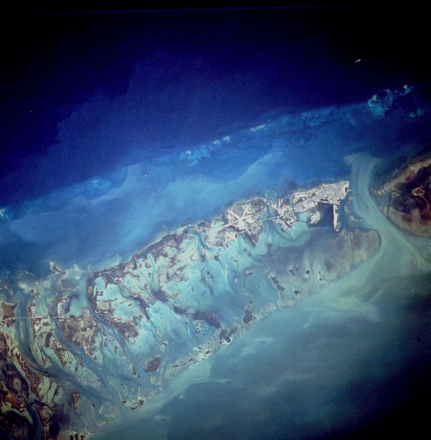 |
| STS038-85-103 Florida Keys and Key West, Florida, U.S.A. November 1990 This south-looking, low-oblique photograph captures the southernmost city in the continental United States, Key West, with the runways of the Key West Naval Air Station obvious near the center of the photograph. The island of Key West [4 miles (6 kilometers) long and 2 miles (3 kilometers) wide and located 60 miles (97 kilometers) southwest of the southern tip of Florida] is one of the Florida Keys, a chain of small coral and limestone islands and reefs that curves southwest for 150 miles (240 kilometers) from just south of Miami Beach to Key West. The causeway connecting the mainland with Key West was completed in 1938, just 3 years after the city was rebuilt following extensive hurricane damage. Many of the islands are habitable; they are generally covered with dense growths of low trees, shrubs, and mangrove swamps. The Florida Keys are noted for their tropical vegetation, commercial fisheries, and resorts. Especially popular in winter, Key West is an artist colony, a fishing resort, a commercial shrimping and fishing center, and a cigar manufacturing site. |
| Images: | All Available Images Low-Resolution 102k |
|
| Mission: | STS038 |
|
| Roll - Frame: | 85 - 103 |
|
| Geographical Name: | USA-FLORIDA |
|
| Features: | KEY WEST |
|
| Center Lat x Lon: | 24.5N x 81.5W |
|
| Film Exposure: | N | N=Normal exposure, U=Under exposed, O=Over exposed, F=out of Focus |
| Percentage of Cloud Cover-CLDP: | 0 |
|
| Camera:: | HB |
|
| Camera Tilt: | 27 | LO=Low Oblique, HO=High Oblique, NV=Near Vertical |
| Camera Focal Length: | 250 |
|
| Nadir to Photo Center Direction: | E | The direction from the nadir to the center point, N=North, S=South, E=East, W=West |
| Stereo?: | Y | Y=Yes there is an adjacent picture of the same area, N=No there isn't |
| Orbit Number: | 47 |
|
| Date: | 19901118 | YYYYMMDD |
| Time: | 202009 | GMT HHMMSS |
| Nadir Lat: | 24.9N |
Latitude of suborbital point of spacecraft |
| Nadir Lon: | 82.4W |
Longitude of suborbital point of spacecraft |
| Sun Azimuth: | 230 | Clockwise angle in degrees from north to the sun measured at the nadir point |
| Space Craft Altitude: | 116 | nautical miles |
| Sun Elevation: | 27 | Angle in degrees between the horizon and the sun, measured at the nadir point |
| Land Views: | ISLAND, FOREST |
|
| Water Views: | GULF, BAY, CHANNEL, LAGOON, SWAMP, REEF |
|
| Atmosphere Views: | |
|
| Man Made Views: | URBAN AREA, AIRPORT |
|
| City Views: | KEY WEST |
|
Photo is not associated with any sequences | ||
| NASA Home Page |
JSC Home Page |
JSC Digital Image Collection |
Earth Science & Remote Sensing |
|
This service is provided by the International Space Station program and the JSC Earth Science & Remote Sensing Unit, ARES Division, Exploration Integration Science Directorate.

|