
Geographic Region: YEMEN
Feature: KRAYTAR, COAST
|
Geographic Region: YEMEN Feature: KRAYTAR, COAST |
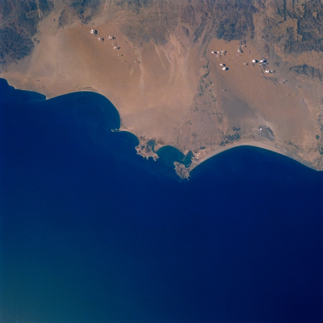 |
| STS038-083-015 Krytar Coast, Aden, Yemen November 1990 The narrow, arid Krytar Coast and the important coastal city of Aden can be seen in this northwest-looking view. The southern Asir Mountains are visible across the top portion of the image. The waters of the Gulf of Aden covers the bottom half of the image. Strategically located just to the east of the Strait of Mandab, the entrance into the Red Sea (not on image), the city of Aden (near the center of the image) is the capital and chief port of southern Yemen. It has a large oil refinery and industries that manufacture soap, cigarettes, and salt. The city and its major port is a major refueling stop for ships and a trading center. Numerous wadis (waterways), which can carry water to the coast during the short rainy season, can be seen coming out of the mountains to the north and reaching southward toward the Gulf of Aden. The irrigated area along the right center of the image is part of a river valley that extends to the coast and the city of Zinjibar. |
| Images: | All Available Images Low-Resolution 268k |
|
| Mission: | STS038 |
|
| Roll - Frame: | 83 - 15 |
|
| Geographical Name: | YEMEN |
|
| Features: | KRAYTAR, COAST |
|
| Center Lat x Lon: | 13.0N x 45.0E |
|
| Film Exposure: | N | N=Normal exposure, U=Under exposed, O=Over exposed, F=out of Focus |
| Percentage of Cloud Cover-CLDP: | 5 |
|
| Camera:: | HB |
|
| Camera Tilt: | 18 | LO=Low Oblique, HO=High Oblique, NV=Near Vertical |
| Camera Focal Length: | 100 |
|
| Nadir to Photo Center Direction: | NW | The direction from the nadir to the center point, N=North, S=South, E=East, W=West |
| Stereo?: | Y | Y=Yes there is an adjacent picture of the same area, N=No there isn't |
| Orbit Number: | 40 |
|
| Date: | 19901118 | YYYYMMDD |
| Time: | 094732 | GMT HHMMSS |
| Nadir Lat: | 12.6N |
Latitude of suborbital point of spacecraft |
| Nadir Lon: | 45.5E |
Longitude of suborbital point of spacecraft |
| Sun Azimuth: | 207 | Clockwise angle in degrees from north to the sun measured at the nadir point |
| Space Craft Altitude: | 121 | nautical miles |
| Sun Elevation: | 55 | Angle in degrees between the horizon and the sun, measured at the nadir point |
| Land Views: | MOUNTAIN, DESERT |
|
| Water Views: | GULF |
|
| Atmosphere Views: | |
|
| Man Made Views: | URBAN AREA, PORT |
|
| City Views: | ADEN |
|
Photo is not associated with any sequences | ||
| NASA Home Page |
JSC Home Page |
JSC Digital Image Collection |
Earth Science & Remote Sensing |
|
This service is provided by the International Space Station program and the JSC Earth Science & Remote Sensing Unit, ARES Division, Exploration Integration Science Directorate.

|