Geographic Region: LOYALTY ISLANDS
Feature: LIFOU ISLAND,WE,AFLD
|
Geographic Region: LOYALTY ISLANDS Feature: LIFOU ISLAND,WE,AFLD |
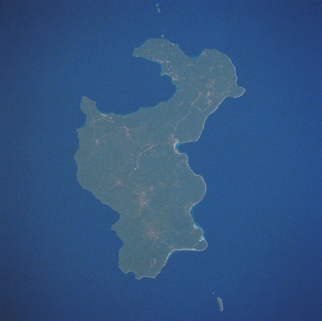 |
| STS038-074-087 Lifou Island, Loyality Islands November 1990 The largest and most important island of the Loyality Islands, Lifou, can be seen in this northwest-looking view. Irregular in shape, Lifou Island is 50 miles (81 km) long and 10 to 15 miles (16 to 24 km) wide. The island is flat with no hills or rivers, but has abundant vegetation, fertile soils, and terraced cliffs. Lifou Island is a former coral atoll that was part of a submerged volcano. Nearly 2 million years ago, the island was uplifted to its present shape and elevation. Tourism is a major industry on the island. Chief exports include copra, rubber, and sugarcane. The water, since there are no rivers on Lifou, comes from rain that seeps through the calcareous soil and forms freshwater ponds. The major city on Lifou is We, which is located near the center of the image. |
| Images: | All Available Images Low-Resolution 314k |
|
| Mission: | STS038 |
|
| Roll - Frame: | 74 - 87 |
|
| Geographical Name: | LOYALTY ISLANDS |
|
| Features: | LIFOU ISLAND,WE,AFLD |
|
| Center Lat x Lon: | 20.9S x 167.2E |
|
| Film Exposure: | N | N=Normal exposure, U=Under exposed, O=Over exposed, F=out of Focus |
| Percentage of Cloud Cover-CLDP: | 0 |
|
| Camera:: | HB |
|
| Camera Tilt: | 36 | LO=Low Oblique, HO=High Oblique, NV=Near Vertical |
| Camera Focal Length: | 250 |
|
| Nadir to Photo Center Direction: | NW | The direction from the nadir to the center point, N=North, S=South, E=East, W=West |
| Stereo?: | N | Y=Yes there is an adjacent picture of the same area, N=No there isn't |
| Orbit Number: | 15 |
|
| Date: | 19901116 | YYYYMMDD |
| Time: | 214022 | GMT HHMMSS |
| Nadir Lat: | 21.9S |
Latitude of suborbital point of spacecraft |
| Nadir Lon: | 168.6E |
Longitude of suborbital point of spacecraft |
| Sun Azimuth: | 94 | Clockwise angle in degrees from north to the sun measured at the nadir point |
| Space Craft Altitude: | 142 | nautical miles |
| Sun Elevation: | 50 | Angle in degrees between the horizon and the sun, measured at the nadir point |
| Land Views: | ISLAND, FOREST, HILL, COAST |
|
| Water Views: | |
|
| Atmosphere Views: | |
|
| Man Made Views: | |
|
| City Views: | |
|
Photo is not associated with any sequences | ||
| NASA Home Page |
JSC Home Page |
JSC Digital Image Collection |
Earth Science & Remote Sensing |
|
This service is provided by the International Space Station program and the JSC Earth Science & Remote Sensing Unit, ARES Division, Exploration Integration Science Directorate.

|