Geographic Region: SENEGAL
Feature: CAHEU, CASAMANCE RIVERS
|
Geographic Region: SENEGAL Feature: CAHEU, CASAMANCE RIVERS |
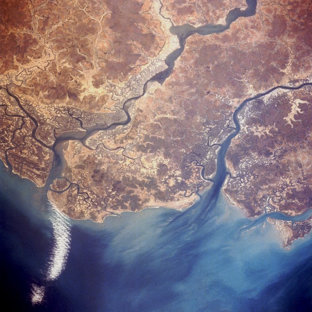 |
| STS037-084-067 Senegal and Guinea-Bissau, Africa April 1991 The coastal areas of two of west Africa's smaller countries, Senegal and Guinea-Bissau, are revealed in this low-oblique, northeast-looking photograph. The boundary between the two countries almost bisects the peninsula formed by the Casamance River to the north (in Senegal) and the Rio Cacheu to the south (in Guinea-Bissau). Both countries have low-lying coastal plains with many rivers and some broad, swampy estuaries. These areas are part of west Africa's better watered coastal states. Mangrove forests (darker, uniform areas) lie along both major rivers. Historically, Senegal has had close political and economic ties with France, and Guinea-Bissau was a Portuguese colonial possession until 1974. The economies of both countries are almost entirely agricultural, ranging from peanut production in Senegal to a variety of crops in Guinea-Bissau; however, both countries' imports in foodstuffs exceed their exports. |
| Images: | All Available Images Low-Resolution 158k |
|
| Mission: | STS037 |
|
| Roll - Frame: | 84 - 67 |
|
| Geographical Name: | SENEGAL |
|
| Features: | CAHEU, CASAMANCE RIVERS |
|
| Center Lat x Lon: | 12.5N x 16W |
|
| Film Exposure: | N | N=Normal exposure, U=Under exposed, O=Over exposed, F=out of Focus |
| Percentage of Cloud Cover-CLDP: | 5 |
|
| Camera:: | HB |
|
| Camera Tilt: | LO | LO=Low Oblique, HO=High Oblique, NV=Near Vertical |
| Camera Focal Length: | 250 |
|
| Nadir to Photo Center Direction: | The direction from the nadir to the center point, N=North, S=South, E=East, W=West |
|
| Stereo?: | Y | Y=Yes there is an adjacent picture of the same area, N=No there isn't |
| Orbit Number: | |
|
| Date: | 199104__ | YYYYMMDD |
| Time: | GMT HHMMSS |
|
| Nadir Lat: | N |
Latitude of suborbital point of spacecraft |
| Nadir Lon: | E |
Longitude of suborbital point of spacecraft |
| Sun Azimuth: | Clockwise angle in degrees from north to the sun measured at the nadir point |
|
| Space Craft Altitude: | nautical miles |
|
| Sun Elevation: | Angle in degrees between the horizon and the sun, measured at the nadir point |
|
| Land Views: | COAST, PLAIN, HILL |
|
| Water Views: | RIVER, ESTUARY, SWAMP |
|
| Atmosphere Views: | |
|
| Man Made Views: | AGRICULTURE |
|
| City Views: | |
|
Photo is not associated with any sequences | ||
| NASA Home Page |
JSC Home Page |
JSC Digital Image Collection |
Earth Science & Remote Sensing |
|
This service is provided by the International Space Station program and the JSC Earth Science & Remote Sensing Unit, ARES Division, Exploration Integration Science Directorate.

|