Geographic Region: SENEGAL
Feature: DAKAR
|
Geographic Region: SENEGAL Feature: DAKAR |
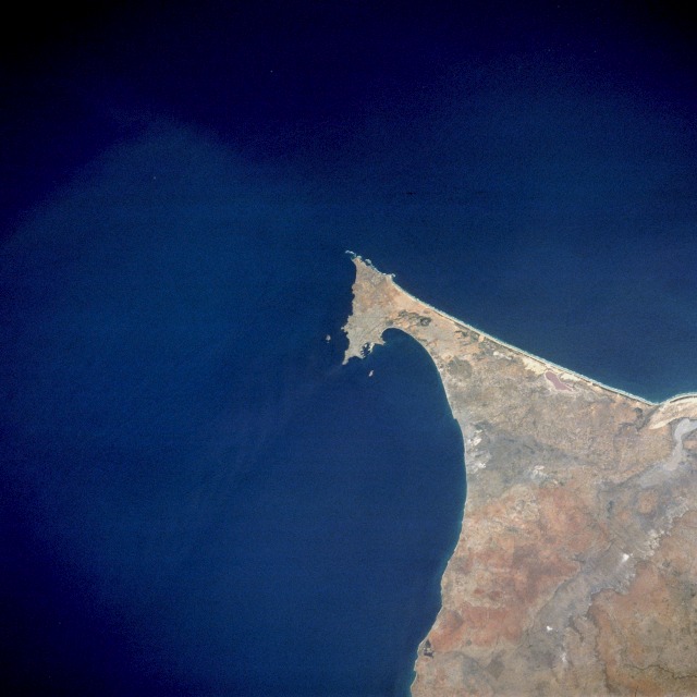 |
| STS037-084-061 Dakar, Senegal April 1991 Dakar, the capital of Senegal, appears in this northeast-looking, low-oblique photograph. The city, with a population of almost 2 million on the southern tip of the Cape Verde Peninsula, has one of the best harbors on the Atlantic coast of Africa. Dakar has several distinctions--it is the westernmost point of the African continent, the African city closest to South America, the sub-Saharan port nearest to western Europe, and an important station on the western trade route to and from South Africa. Dakar's strategic location has made it an intercontinental maritime and air center, as well as an international rail terminus for Africa. Manufacturing industries include refined sugar, peanut oil, fertilizers, cement, textiles, fishing products, food processing, and handicrafts. Dakar is blessed with some of the finest medical facilities in Africa, including the Pasteur Institute. |
| Images: | All Available Images Low-Resolution 84k |
|
| Mission: | STS037 |
|
| Roll - Frame: | 84 - 61 |
|
| Geographical Name: | SENEGAL |
|
| Features: | DAKAR |
|
| Center Lat x Lon: | 14.5N x 17.5W |
|
| Film Exposure: | N | N=Normal exposure, U=Under exposed, O=Over exposed, F=out of Focus |
| Percentage of Cloud Cover-CLDP: | 0 |
|
| Camera:: | HB |
|
| Camera Tilt: | NV | LO=Low Oblique, HO=High Oblique, NV=Near Vertical |
| Camera Focal Length: | 250 |
|
| Nadir to Photo Center Direction: | The direction from the nadir to the center point, N=North, S=South, E=East, W=West |
|
| Stereo?: | Y | Y=Yes there is an adjacent picture of the same area, N=No there isn't |
| Orbit Number: | |
|
| Date: | 199104__ | YYYYMMDD |
| Time: | GMT HHMMSS |
|
| Nadir Lat: | N |
Latitude of suborbital point of spacecraft |
| Nadir Lon: | E |
Longitude of suborbital point of spacecraft |
| Sun Azimuth: | Clockwise angle in degrees from north to the sun measured at the nadir point |
|
| Space Craft Altitude: | nautical miles |
|
| Sun Elevation: | Angle in degrees between the horizon and the sun, measured at the nadir point |
|
| Land Views: | COAST, PENINSULA |
|
| Water Views: | OCEAN, LAGOON |
|
| Atmosphere Views: | |
|
| Man Made Views: | URBAN AREA |
|
| City Views: | |
|
Photo is not associated with any sequences | ||
| NASA Home Page |
JSC Home Page |
JSC Digital Image Collection |
Earth Science & Remote Sensing |
|
This service is provided by the International Space Station program and the JSC Earth Science & Remote Sensing Unit, ARES Division, Exploration Integration Science Directorate.

|