Geographic Region: MAURITANIA
Feature: NEAR VILLAGE OF ATAR
|
Geographic Region: MAURITANIA Feature: NEAR VILLAGE OF ATAR |
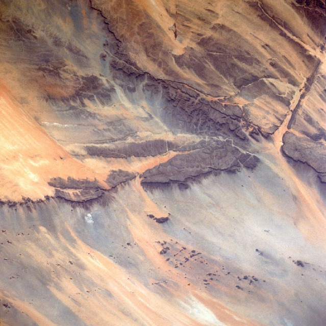 |
| STS037-084-021 Amojjar Pass, Mauritania April 1991 Millions of years ago most of this very arid region in northwest Mauritania was made up of large sandstone plateaus that looked like the brownish sandstone tabletop terrain that exists in the area today. This entire region has undergone a dramatic climatic change. It is apparent when looking at the existing landscape that substantial rainfall altered the former landscape into one of broad canyons bounded by craggy, vertical cliffs. The area now averages approximately 4 inches (10 centimeters) of rainfall annually, sometimes decreasing to as little as 1 inch (25 centimeters). The base of these cliffs is hidden by numerous talus slopes visible even at this small scale. The Amojjar Pass, near the town of Atar, is in the canyon just east of the large flat-topped plateau (center of the photograph). The pass is an important ground transportation link because it provides a somewhat protected roadway connecting the two Mauritania cities of Fdérik and Nouakchott, the capital. The effects of wind erosion on the landscape are evidenced by the northeast-southwest orientation of the sand streaks. |
| Images: | All Available Images Low-Resolution 140k |
|
| Mission: | STS037 |
|
| Roll - Frame: | 84 - 21 |
|
| Geographical Name: | MAURITANIA |
|
| Features: | NEAR VILLAGE OF ATAR |
|
| Center Lat x Lon: | 20.5N x 13W |
|
| Film Exposure: | U | N=Normal exposure, U=Under exposed, O=Over exposed, F=out of Focus |
| Percentage of Cloud Cover-CLDP: | 0 |
|
| Camera:: | HB |
|
| Camera Tilt: | LO | LO=Low Oblique, HO=High Oblique, NV=Near Vertical |
| Camera Focal Length: | 250 |
|
| Nadir to Photo Center Direction: | The direction from the nadir to the center point, N=North, S=South, E=East, W=West |
|
| Stereo?: | Y | Y=Yes there is an adjacent picture of the same area, N=No there isn't |
| Orbit Number: | |
|
| Date: | 199104__ | YYYYMMDD |
| Time: | GMT HHMMSS |
|
| Nadir Lat: | N |
Latitude of suborbital point of spacecraft |
| Nadir Lon: | E |
Longitude of suborbital point of spacecraft |
| Sun Azimuth: | Clockwise angle in degrees from north to the sun measured at the nadir point |
|
| Space Craft Altitude: | nautical miles |
|
| Sun Elevation: | Angle in degrees between the horizon and the sun, measured at the nadir point |
|
| Land Views: | DESERT, MOUNTAIN, PLATEAU |
|
| Water Views: | RIVER |
|
| Atmosphere Views: | |
|
| Man Made Views: | |
|
| City Views: | |
|
Photo is not associated with any sequences | ||
| NASA Home Page |
JSC Home Page |
JSC Digital Image Collection |
Earth Science & Remote Sensing |
|
This service is provided by the International Space Station program and the JSC Earth Science & Remote Sensing Unit, ARES Division, Exploration Integration Science Directorate.

|