Geographic Region: SENEGAL
Feature: DAKAR, SADOUM RIVER
|
Geographic Region: SENEGAL Feature: DAKAR, SADOUM RIVER |
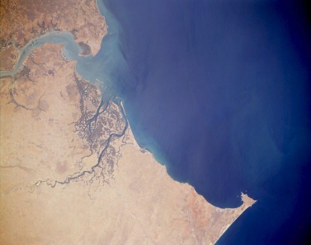 |
| STS037-153-0CF Coastal Senegal and Gambia April 1991 Dakar (with a population of approximately 2 million), the capital of Senegal, is situated on the very pronounced peninsula (near the northern edge of the photograph); the extreme western point on this peninsula is Cape Vert. Lying along the southwest coast of Senegal is a fairly extensive coastal wetlands area consisting of low-lying marshes, numerous stream tributaries, and stands of mangrove forests (darker areas). Banjul (formerly Bathurst) with a population of fewer than 50 000, the capital of Gambia, is located on a small peninsula on the south side of the mouth of the Gambia River. The wide estuary of the Gambia River, which also has mangrove stands, is easily seen near the southeast edge of the photograph. Rainfall amounts average more than 60 inches (152 centimeters) in the south and decrease to less than 10 inches (25 centimeters) in the north. Rice, cotton, and peanuts are the leading crops in these two agricultural countries. |
| Images: | Images: | NO IMAGES YET | |||
| Mission: | STS037 |
||||
| Roll - Frame: | 153 - CF |
||||
| Geographical Name: | SENEGAL |
||||
| Features: | DAKAR, SADOUM RIVER |
||||
| Center Lat x Lon: | 14.0N x 17.5W |
||||
| Film Exposure: | N | N=Normal exposure, U=Under exposed, O=Over exposed, F=out of Focus |
|||
| Percentage of Cloud Cover-CLDP: | 0 |
||||
| Camera:: | LH |
||||
| Camera Tilt: | LO | LO=Low Oblique, HO=High Oblique, NV=Near Vertical |
|||
| Camera Focal Length: | 250 |
||||
| Nadir to Photo Center Direction: | The direction from the nadir to the center point, N=North, S=South, E=East, W=West |
||||
| Stereo?: | Y | Y=Yes there is an adjacent picture of the same area, N=No there isn't |
|||
| Orbit Number: | |
||||
| Date: | 199104__ | YYYYMMDD |
|||
| Time: | GMT HHMMSS |
||||
| Nadir Lat: | N |
Latitude of suborbital point of spacecraft | |||
| Nadir Lon: | E |
Longitude of suborbital point of spacecraft | |||
| Sun Azimuth: | Clockwise angle in degrees from north to the sun measured at the nadir point |
||||
| Space Craft Altitude: | nautical miles |
||||
| Sun Elevation: | Angle in degrees between the horizon and the sun, measured at the nadir point |
||||
| Land Views: | COAST, DESERT, PENINSULA, PLAIN |
||||
| Water Views: | RIVER, OCEAN, ESTUARY |
||||
| Atmosphere Views: | |
||||
| Man Made Views: | URBAN AREA |
||||
| City Views: | |
||||
Photo is not associated with any sequences | |||||
| NASA Home Page |
JSC Home Page |
JSC Digital Image Collection |
Earth Science & Remote Sensing |
|
This service is provided by the International Space Station program and the JSC Earth Science & Remote Sensing Unit, ARES Division, Exploration Integration Science Directorate.

|