
Geographic Region: SOCOTRA
Feature: ENTIRE ISLAND-SUNGLINT
|
Geographic Region: SOCOTRA Feature: ENTIRE ISLAND-SUNGLINT |
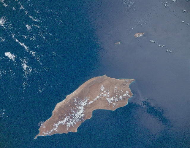 |
| STS037-151-236 Socotra Island, Yemen April 1991 Located at the mouth of the Gulf of Aden 248 miles (400 km) south of the Saudi Arabian Peninsula, and 140 miles (225 km) from the Horn of Africa in northeast Somalia, the island of Socotra is 81 miles (130 km) long and 25 miles (40 km) wide, and covers an area of 1383 square miles (3582 sq km). The semiarid island is mountainous with a narrow coastal plain. Interior mountains rise to 5000 feet (1525 meters). The chief products of the island are dates, ghee, tobacco, and fish. |
| Images: | All Available Images Low-Resolution 302k |
|
| Mission: | STS037 |
|
| Roll - Frame: | 151 - 236 |
|
| Geographical Name: | SOCOTRA |
|
| Features: | ENTIRE ISLAND-SUNGLINT |
|
| Center Lat x Lon: | 12.5N x 53.5E |
|
| Film Exposure: | N | N=Normal exposure, U=Under exposed, O=Over exposed, F=out of Focus |
| Percentage of Cloud Cover-CLDP: | 10 |
|
| Camera:: | LH |
|
| Camera Tilt: | 5 | LO=Low Oblique, HO=High Oblique, NV=Near Vertical |
| Camera Focal Length: | 250 |
|
| Nadir to Photo Center Direction: | SE | The direction from the nadir to the center point, N=North, S=South, E=East, W=West |
| Stereo?: | N | Y=Yes there is an adjacent picture of the same area, N=No there isn't |
| Orbit Number: | 13 |
|
| Date: | 19910406 | YYYYMMDD |
| Time: | 092407 | GMT HHMMSS |
| Nadir Lat: | 12.8N |
Latitude of suborbital point of spacecraft |
| Nadir Lon: | 53.3E |
Longitude of suborbital point of spacecraft |
| Sun Azimuth: | 245 | Clockwise angle in degrees from north to the sun measured at the nadir point |
| Space Craft Altitude: | 244 | nautical miles |
| Sun Elevation: | 75 | Angle in degrees between the horizon and the sun, measured at the nadir point |
| Land Views: | ISLAND, COAST, MOUNTAIN |
|
| Water Views: | GULF |
|
| Atmosphere Views: | |
|
| Man Made Views: | |
|
| City Views: | |
|
Photo is not associated with any sequences | ||
| NASA Home Page |
JSC Home Page |
JSC Digital Image Collection |
Earth Science & Remote Sensing |
|
This service is provided by the International Space Station program and the JSC Earth Science & Remote Sensing Unit, ARES Division, Exploration Integration Science Directorate.

|