Geographic Region: PAKISTAN
Feature: MOUNTAINS, INDUS RIVER
|
Geographic Region: PAKISTAN Feature: MOUNTAINS, INDUS RIVER |
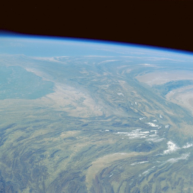 |
| STS036-076-075 Makran Mountains, Pakistan March 1990 While the collision of the Australian-Indian Tectonic Plate and the Eurasian Plate created the Himalayan Mountains millions of years ago, the land masses on either side of this northward force formed the folded, generally north-south trending Makran, Kirthar, and Sulaiman Ranges along the western border of Pakistan shown in this high-oblique, southwest-viewing photograph. The gently arcing northern Sulaiman Range splits into two separate ranges--the north-south trending Kirthar Range immediately west of the Indus River floodplain and the Makran Range that arcs westward near the coast and extends into southeastern Iran. The Chagai Hills, a smaller east-west trending range separates two sandy western deserts and form the boundary between southern Afghanistan and southwestern Pakistan. A small segment of the Indus River and its broad floodplain are visible along the eastern edge of the photograph. |
| Images: | All Available Images Low-Resolution 84k |
|
| Mission: | STS036 |
|
| Roll - Frame: | 76 - 75 |
|
| Geographical Name: | PAKISTAN |
|
| Features: | MOUNTAINS, INDUS RIVER |
|
| Center Lat x Lon: | 28.5N x 67.5E |
|
| Film Exposure: | N | N=Normal exposure, U=Under exposed, O=Over exposed, F=out of Focus |
| Percentage of Cloud Cover-CLDP: | 5 |
|
| Camera:: | HB |
|
| Camera Tilt: | HO | LO=Low Oblique, HO=High Oblique, NV=Near Vertical |
| Camera Focal Length: | 100 |
|
| Nadir to Photo Center Direction: | SW | The direction from the nadir to the center point, N=North, S=South, E=East, W=West |
| Stereo?: | N | Y=Yes there is an adjacent picture of the same area, N=No there isn't |
| Orbit Number: | 48 |
|
| Date: | 19900303 | YYYYMMDD |
| Time: | 061934 | GMT HHMMSS |
| Nadir Lat: | 33.4N |
Latitude of suborbital point of spacecraft |
| Nadir Lon: | 71.4E |
Longitude of suborbital point of spacecraft |
| Sun Azimuth: | 155 | Clockwise angle in degrees from north to the sun measured at the nadir point |
| Space Craft Altitude: | 126 | nautical miles |
| Sun Elevation: | 47 | Angle in degrees between the horizon and the sun, measured at the nadir point |
| Land Views: | MOUNTAIN, VALLEY, DESERT, RANGE |
|
| Water Views: | RIVER |
|
| Atmosphere Views: | |
|
| Man Made Views: | |
|
| City Views: | |
|
Photo is not associated with any sequences | ||
| NASA Home Page |
JSC Home Page |
JSC Digital Image Collection |
Earth Science & Remote Sensing |
|
This service is provided by the International Space Station program and the JSC Earth Science & Remote Sensing Unit, ARES Division, Exploration Integration Science Directorate.

|