Geographic Region: MOZAMBIQUE
Feature: ILHA DO BAZARUTO
|
Geographic Region: MOZAMBIQUE Feature: ILHA DO BAZARUTO |
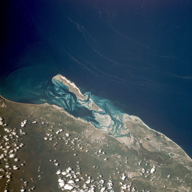 |
| STS036-073-056 Bazaruto Island, Mozambique March 1990 The sandy island of Bazaruto, Mozambique, is located approximately 50 miles (80 kilometers) southeast of the mouth of the Save River. The warm, southward-flowing Mozambique Current seems to contribute to the increasing buildup of the sandy coastline. Because the water along this coastal area is very clear, much of the subsurface channel pattern around the island is discernible. Several narrow lines of plankton bloom (barely visible in the photograph) parallel the shoreline. The coastal plains show numerous lakes and a swampy environment that appears to be karst topography. Underlying the area is limestone rock that has eroded into a pockmarked landscape, creating water-filled sinkholes. Rainfall amounts in this humid equatorial climate range between 20 and 40 inches (50 and 100 centimeters) annually. |
| Images: | All Available Images Low-Resolution 109k |
|
| Mission: | STS036 |
|
| Roll - Frame: | 73 - 56 |
|
| Geographical Name: | MOZAMBIQUE |
|
| Features: | ILHA DO BAZARUTO |
|
| Center Lat x Lon: | 22S x 35.5E |
|
| Film Exposure: | N | N=Normal exposure, U=Under exposed, O=Over exposed, F=out of Focus |
| Percentage of Cloud Cover-CLDP: | 10 |
|
| Camera:: | HB |
|
| Camera Tilt: | 23 | LO=Low Oblique, HO=High Oblique, NV=Near Vertical |
| Camera Focal Length: | 100 |
|
| Nadir to Photo Center Direction: | NE | The direction from the nadir to the center point, N=North, S=South, E=East, W=West |
| Stereo?: | Y | Y=Yes there is an adjacent picture of the same area, N=No there isn't |
| Orbit Number: | 35 |
|
| Date: | 19900302 | YYYYMMDD |
| Time: | 111439 | GMT HHMMSS |
| Nadir Lat: | 22.6S |
Latitude of suborbital point of spacecraft |
| Nadir Lon: | 34.8E |
Longitude of suborbital point of spacecraft |
| Sun Azimuth: | 305 | Clockwise angle in degrees from north to the sun measured at the nadir point |
| Space Craft Altitude: | 132 | nautical miles |
| Sun Elevation: | 65 | Angle in degrees between the horizon and the sun, measured at the nadir point |
| Land Views: | COAST, ISLAND, PLAIN |
|
| Water Views: | CHANNEL, SWAMP, RIVER |
|
| Atmosphere Views: | |
|
| Man Made Views: | |
|
| City Views: | |
|
Photo is not associated with any sequences | ||
| NASA Home Page |
JSC Home Page |
JSC Digital Image Collection |
Earth Science & Remote Sensing |
|
This service is provided by the International Space Station program and the JSC Earth Science & Remote Sensing Unit, ARES Division, Exploration Integration Science Directorate.

|