Geographic Region: ALGERIA
Feature: TASSILI NAJJER,IRARREN D
|
Geographic Region: ALGERIA Feature: TASSILI NAJJER,IRARREN D |
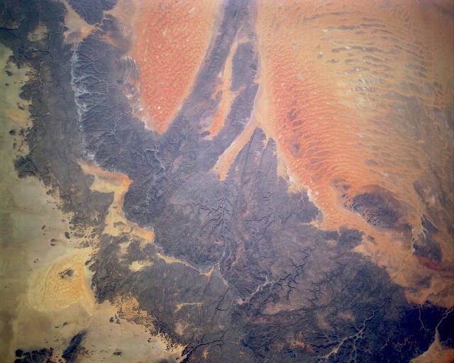 |
| STS036-152-252 Tassili-N'-Ajjer (Plateau), Algeria March 1990 The Tassili-N'-Ajjer, located in southeastern Algeria and considered part of the northern Sahara Desert, is a series of eroded sandstone plateaus (darker gray areas). Within these sandstone plateaus are numerous narrow, steep-sided valleys and ravines. These desert rocks have been described as ranging in color from dull red to black, depending on the level of oxidation that has occurred and the level of metallic oxides deposited on the surface of the rocks. Several smaller sand seas, most notably the triangular Tifernine Dunes, can be seen toward the western part of the photograph. Both the Tifernine Dune field and the larger area of dunes to the east result from complex wind regimes that prevail throughout this arid region that receives less than 4 inches (10 centimeters) of precipitation per year. (Refer to photograph STS-070-705-094 for more detailed information on the Tifernine Dunes.) |
| Images: | All Available Images Low-Resolution 104k |
|
| Mission: | STS036 |
|
| Roll - Frame: | 152 - 252 |
|
| Geographical Name: | ALGERIA |
|
| Features: | TASSILI NAJJER,IRARREN D |
|
| Center Lat x Lon: | 26.0N x 7.5E |
|
| Film Exposure: | N | N=Normal exposure, U=Under exposed, O=Over exposed, F=out of Focus |
| Percentage of Cloud Cover-CLDP: | 0 |
|
| Camera:: | LH |
|
| Camera Tilt: | 9 | LO=Low Oblique, HO=High Oblique, NV=Near Vertical |
| Camera Focal Length: | 90 |
|
| Nadir to Photo Center Direction: | E | The direction from the nadir to the center point, N=North, S=South, E=East, W=West |
| Stereo?: | N | Y=Yes there is an adjacent picture of the same area, N=No there isn't |
| Orbit Number: | 67 |
|
| Date: | 19900304 | YYYYMMDD |
| Time: | 103409 | GMT HHMMSS |
| Nadir Lat: | 26.1N |
Latitude of suborbital point of spacecraft |
| Nadir Lon: | 7.2E |
Longitude of suborbital point of spacecraft |
| Sun Azimuth: | 150 | Clockwise angle in degrees from north to the sun measured at the nadir point |
| Space Craft Altitude: | 116 | nautical miles |
| Sun Elevation: | 54 | Angle in degrees between the horizon and the sun, measured at the nadir point |
| Land Views: | DESERT, DUNE, PLATEAU, ESCARPMENT |
|
| Water Views: | |
|
| Atmosphere Views: | |
|
| Man Made Views: | |
|
| City Views: | |
|
Photo is not associated with any sequences | ||
| NASA Home Page |
JSC Home Page |
JSC Digital Image Collection |
Earth Science & Remote Sensing |
|
This service is provided by the International Space Station program and the JSC Earth Science & Remote Sensing Unit, ARES Division, Exploration Integration Science Directorate.

|