Geographic Region: SPAIN
Feature: BISCAY COAST,CANTABRICA MT
|
Geographic Region: SPAIN Feature: BISCAY COAST,CANTABRICA MT |
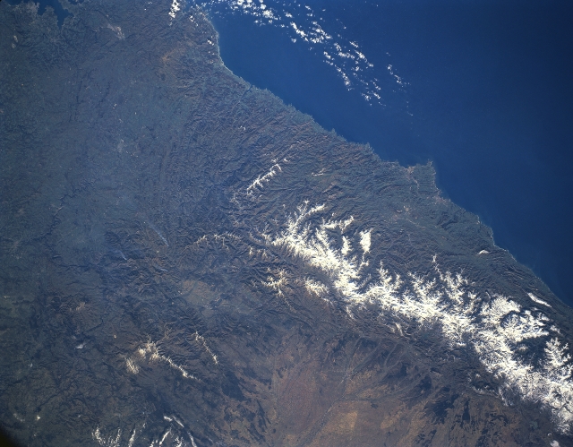 |
| STS036-152-248 Cantabrian Mountains, Spain March 1990 The Cantabrian Mountains are a physical and climatic barrier to northern Spain. The east to west trending limestone mountains extend for 300 miles (483 km) along the northern coastline of Spain. The mountains' northern slopes drop steeply toward the Asturias Coast while the southern mountain slopes descend more gradually toward the arid interior. This late winter image accentuates the fact (through marked color differences) that the windward (north) side of the mountains receives substantially more precipitation than the drier leeward (south) slopes. This image also shows that an accumulation of snow is visible on the higher elevations, usually exceeding 7000 feet (2134 meters) above sea level. The Cantabrian Mountains have provided a constant source of iron and coal for Spain during the last few centuries. |
| Images: | All Available Images Low-Resolution 274k |
|
| Mission: | STS036 |
|
| Roll - Frame: | 152 - 248 |
|
| Geographical Name: | SPAIN |
|
| Features: | BISCAY COAST,CANTABRICA MT |
|
| Center Lat x Lon: | 43.0N x 6.5W |
|
| Film Exposure: | N | N=Normal exposure, U=Under exposed, O=Over exposed, F=out of Focus |
| Percentage of Cloud Cover-CLDP: | 10 |
|
| Camera:: | LH |
|
| Camera Tilt: | 12 | LO=Low Oblique, HO=High Oblique, NV=Near Vertical |
| Camera Focal Length: | 90 |
|
| Nadir to Photo Center Direction: | S | The direction from the nadir to the center point, N=North, S=South, E=East, W=West |
| Stereo?: | Y | Y=Yes there is an adjacent picture of the same area, N=No there isn't |
| Orbit Number: | 67 |
|
| Date: | 19900304 | YYYYMMDD |
| Time: | 102857 | GMT HHMMSS |
| Nadir Lat: | 43.4N |
Latitude of suborbital point of spacecraft |
| Nadir Lon: | 6.5W |
Longitude of suborbital point of spacecraft |
| Sun Azimuth: | 141 | Clockwise angle in degrees from north to the sun measured at the nadir point |
| Space Craft Altitude: | 115 | nautical miles |
| Sun Elevation: | 32 | Angle in degrees between the horizon and the sun, measured at the nadir point |
| Land Views: | MOUNTAIN |
|
| Water Views: | BAY |
|
| Atmosphere Views: | |
|
| Man Made Views: | |
|
| City Views: | |
|
Photo is not associated with any sequences | ||
| NASA Home Page |
JSC Home Page |
JSC Digital Image Collection |
Earth Science & Remote Sensing |
|
This service is provided by the International Space Station program and the JSC Earth Science & Remote Sensing Unit, ARES Division, Exploration Integration Science Directorate.

|