
Geographic Region: CROATIA
Feature: ISTRIA PEN,TRIESTE,G. VEN
|
Geographic Region: CROATIA Feature: ISTRIA PEN,TRIESTE,G. VEN |
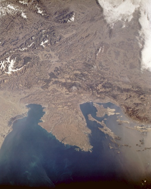 |
| STS036-152-237 Northeast Coastal Area, Adriatic Sea March 1990 The rough, hilly terrain and low mountains northeast of the Adriatic Sea are evident in this low-oblique, northeast-looking photograph. The eastern boundary of the Alps, shown along the western margin of the photograph, ends in northeastern Italy and northwestern Slovenia. The Istra Peninsula, the very large land mass extending southward into the Adriatic Sea, is bordered on the west by the Gulf of Venice (and the smaller Gulf of Trieste) and on the east by the Gulf of Kvarner. The boundaries of northeastern Italy (including the city of Trieste), Slovenia, and Croatia and the capital cities of Ljubljana (Slovenia) and Zagreb (Croatia) are not discernible at this scale. The offshore islands southeast of the peninsula belong to Croatia. Slovenia is almost land locked, except for a small corridor that extends between Italy and Croatia along the northwest coast of the Istra Peninsula. Many of the mountains contain dense forests (dark areas), whereas the mountain valleys appear light green and tan. Part of the coastal plain of northeastern Italy is visible along the western margin of the photograph. |
| Images: | All Available Images Low-Resolution 100k |
|
| Mission: | STS036 |
|
| Roll - Frame: | 152 - 237 |
|
| Geographical Name: | CROATIA |
|
| Features: | ISTRIA PEN,TRIESTE,G. VEN |
|
| Center Lat x Lon: | 45.5N x 14.5E |
|
| Film Exposure: | N | N=Normal exposure, U=Under exposed, O=Over exposed, F=out of Focus |
| Percentage of Cloud Cover-CLDP: | 10 |
|
| Camera:: | LH |
|
| Camera Tilt: | 20 | LO=Low Oblique, HO=High Oblique, NV=Near Vertical |
| Camera Focal Length: | 90 |
|
| Nadir to Photo Center Direction: | E | The direction from the nadir to the center point, N=North, S=South, E=East, W=West |
| Stereo?: | Y | Y=Yes there is an adjacent picture of the same area, N=No there isn't |
| Orbit Number: | 66 |
|
| Date: | 19900304 | YYYYMMDD |
| Time: | 085915 | GMT HHMMSS |
| Nadir Lat: | 45.4N |
Latitude of suborbital point of spacecraft |
| Nadir Lon: | 13.8E |
Longitude of suborbital point of spacecraft |
| Sun Azimuth: | 140 | Clockwise angle in degrees from north to the sun measured at the nadir point |
| Space Craft Altitude: | 115 | nautical miles |
| Sun Elevation: | 30 | Angle in degrees between the horizon and the sun, measured at the nadir point |
| Land Views: | PENINSULA, COAST, ISLAND, MOUNTAIN, VALLEY |
|
| Water Views: | BAY, RIVER |
|
| Atmosphere Views: | |
|
| Man Made Views: | |
|
| City Views: | |
|
Photo is not associated with any sequences | ||
| NASA Home Page |
JSC Home Page |
JSC Digital Image Collection |
Earth Science & Remote Sensing |
|
This service is provided by the International Space Station program and the JSC Earth Science & Remote Sensing Unit, ARES Division, Exploration Integration Science Directorate.

|