
Geographic Region: SWITZERLAND
Feature: PAN-ALPS, RHINE RIVER
|
Geographic Region: SWITZERLAND Feature: PAN-ALPS, RHINE RIVER |
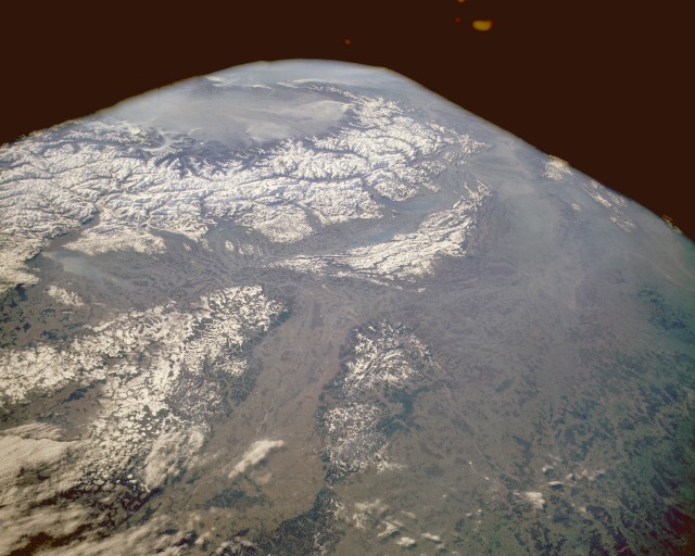 |
| STS036-152-229 The Alps, Rhine River Valley, South-Central Europe May 1989 The impressive snow-covered Alpine mountains and the hills and low mountains of eastern France, northern Italy, Switzerland, and southern Germany are seen in this low-oblique, south-looking photograph of south-central Europe. Two snow-covered areas are distinguishable viewing clockwise from the north--part of the complex series of the Alps of eastern France, northern Italy, and Switzerland and the large heavily forested hills and low mountains that range from 2000 to 3000 feet (610 to 915 meters) above sea level, which include the Vosges Mountains of eastern France and the Black Forest of southern Germany, separated by the north-flowing Rhine River and its valley. The Alps do not have extremely high elevations in comparison with other continental mountain systems; however, many of the peaks exceed 10 000 feet (3500 meters). While the hazy, cloud-filled Po River Valley of Italy is visible across the southern horizon, the Rhone River Valley and Lake Geneva are barely visible. |
| Images: | All Available Images Low-Resolution 100k |
|
| Mission: | STS036 |
|
| Roll - Frame: | 152 - 229 |
|
| Geographical Name: | SWITZERLAND |
|
| Features: | PAN-ALPS, RHINE RIVER |
|
| Center Lat x Lon: | 47.5N x 8.0E |
|
| Film Exposure: | N | N=Normal exposure, U=Under exposed, O=Over exposed, F=out of Focus |
| Percentage of Cloud Cover-CLDP: | 20 |
|
| Camera:: | LH |
|
| Camera Tilt: | HO | LO=Low Oblique, HO=High Oblique, NV=Near Vertical |
| Camera Focal Length: | 90 |
|
| Nadir to Photo Center Direction: | S | The direction from the nadir to the center point, N=North, S=South, E=East, W=West |
| Stereo?: | N | Y=Yes there is an adjacent picture of the same area, N=No there isn't |
| Orbit Number: | 66 |
|
| Date: | 19900304 | YYYYMMDD |
| Time: | 085743 | GMT HHMMSS |
| Nadir Lat: | 49.9N |
Latitude of suborbital point of spacecraft |
| Nadir Lon: | 7.7E |
Longitude of suborbital point of spacecraft |
| Sun Azimuth: | 135 | Clockwise angle in degrees from north to the sun measured at the nadir point |
| Space Craft Altitude: | 115 | nautical miles |
| Sun Elevation: | 24 | Angle in degrees between the horizon and the sun, measured at the nadir point |
| Land Views: | FOREST, MOUNTAIN, VALLEY, GLACIER |
|
| Water Views: | RIVER, LAKE |
|
| Atmosphere Views: | |
|
| Man Made Views: | |
|
| City Views: | |
|
Photo is not associated with any sequences | ||
| NASA Home Page |
JSC Home Page |
JSC Digital Image Collection |
Earth Science & Remote Sensing |
|
This service is provided by the International Space Station program and the JSC Earth Science & Remote Sensing Unit, ARES Division, Exploration Integration Science Directorate.

|